Skip to content

Home

About Us

Advertisement

Contact Us

  • Facebook
  • X
  • Instagram
  • Pinterest
  • WhatsApp
  • RSS Feed
  • TikTok

Dulaney Griffin

Your Trusted Weather Tracker.

Search

Rare Week Out Warning Fires as Powerful Jet Stream Threatens Buffalo to New York City Next Wednesday

Melissa Peel Avatar
Melissa Peel
August 28, 2026
Rare Week Out Warning Fires as Powerful Jet Stream Threatens Buffalo to New York City Next Wednesday

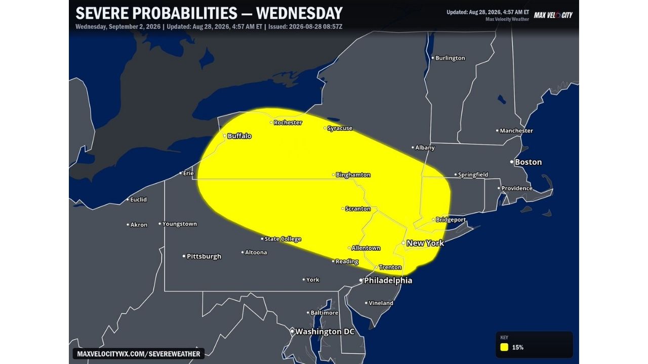
BUFFALO — Forecasters have introduced an elevated severe weather threat for Wednesday, September 2, with weather models showing unusually strong agreement that a powerful upper-level disturbance will track from the eastern Great Lakes into the Mid-Atlantic and southern New England. The risk area, carrying a 15% severe probability, stretches from Buffalo and Rochester through Scranton and Allentown down to New York City and Philadelphia.

Rare Model Agreement Points to a Highly Favorable Setup for Organized Storms

What’s driving forecaster confidence this far out is the unusually strong agreement between weather models on the track of a mid-level jet moving over a warm, humid airmass next Wednesday. That combination creates a highly favorable environment for organized severe storms, and where those favorable conditions overlap most strongly, forecasters have introduced a 15% severe probability zone stretching across a wide swath of the Northeast, anchored by Buffalo and New York City.

From Rochester to Philadelphia, a Six Day Heads Up for Millions

The outlined zone runs roughly 400 miles from Buffalo, Rochester, and Syracuse in western New York, through Binghamton and Scranton, down into Allentown, Reading, and the New York City and Philadelphia metro areas. Issuing a defined risk area nearly a week in advance is uncommon, and reflects just how confident forecasters currently are in both the timing and placement of next Wednesday’s disturbance, even though specific hazard details like wind speed or hail size aren’t yet available this far out.

Six Days Remain Before Wednesday’s Threat Materializes

This is an early, extended-range outlook for a system nearly a week away, and no watches, warnings, or specific hazard numbers have been issued yet. This article will be updated as Wednesday approaches and forecasters refine the outlook with more specific details.

Getting Ahead of Next Wednesday’s Storm Potential

In the days leading up to Wednesday:

  • Check back for updated outlooks, extended-range risk areas often sharpen considerably as the event gets closer
  • Note the broad footprint, if you’re anywhere between Buffalo and New York City, this is worth keeping on your radar
  • Have a severe weather plan ready, regardless of where in the zone you are

As Wednesday approaches:

  • Watch for Day 2 and Day 1 SPC-style outlooks, which will bring more specific timing and hazard details
  • Have a way to receive warnings ready, a weather radio or phone alerts, once the event draws closer

An Unusually Early Look at a Northeast Storm Threat

Forecasters rarely introduce a defined severe weather risk area a full week out, making next Wednesday’s setup notable before a single storm has even formed. With Buffalo and New York City anchoring opposite ends of the same risk zone, millions of residents across the Northeast now have nearly a week of lead time to watch how this unusually well-agreed-upon forecast develops.

For more coverage like this, check back for the latest severe weather updates.

Featured Articles

  • Damaging Wind Gusts and Hail Loom Over Central Wisconsin as Forecasters Lock In on Sunday Evening Storm Threat

    Damaging Wind Gusts and Hail Loom Over Central Wisconsin as Forecasters Lock In on Sunday Evening Storm Threat

    August 28, 2026
  • Isolated Wind and Hail Threat Stretches 700 Miles From Fargo to Denver as Storms Eye Sunday Breakthrough

    Isolated Wind and Hail Threat Stretches 700 Miles From Fargo to Denver as Storms Eye Sunday Breakthrough

    August 28, 2026
  • Explosive Rain Bomb Set to Drench Minnesota and Western Wisconsin as Powerful Jet Dynamics Collide Saturday

    Explosive Rain Bomb Set to Drench Minnesota and Western Wisconsin as Powerful Jet Dynamics Collide Saturday

    August 28, 2026
  • Oppressive 79 Degree Dew Points Set to Blanket Eastern US as Miserable Moisture Surge Targets Millions Next Week

    Oppressive 79 Degree Dew Points Set to Blanket Eastern US as Miserable Moisture Surge Targets Millions Next Week

    August 28, 2026
  • 75 MPH Hurricane Force Winds Set to Slam Salt Lake City and Rapid City Saturday in Explosive Two State Threat

    75 MPH Hurricane Force Winds Set to Slam Salt Lake City and Rapid City Saturday in Explosive Two State Threat

    August 28, 2026

Search

Follow Us on

  • Facebook
  • X
  • Instagram
  • VK
  • Pinterest
  • Last.fm
  • TikTok
  • Telegram
  • WhatsApp
  • RSS Feed

Categories

  • Forecast (58)

About Us

dulaneygriffin

Dulaney Griffin tracks storms, tornado risk, heat and snow across the United States, using National Weather Service and NOAA data. For active warnings in your area, always follow the National Weather Service and your local emergency officials.

Latest Articles

  • Damaging Wind Gusts and Hail Loom Over Central Wisconsin as Forecasters Lock In on Sunday Evening Storm Threat

    Damaging Wind Gusts and Hail Loom Over Central Wisconsin as Forecasters Lock In on Sunday Evening Storm Threat

    August 28, 2026
  • Isolated Wind and Hail Threat Stretches 700 Miles From Fargo to Denver as Storms Eye Sunday Breakthrough

    Isolated Wind and Hail Threat Stretches 700 Miles From Fargo to Denver as Storms Eye Sunday Breakthrough

    August 28, 2026
  • Explosive Rain Bomb Set to Drench Minnesota and Western Wisconsin as Powerful Jet Dynamics Collide Saturday

    Explosive Rain Bomb Set to Drench Minnesota and Western Wisconsin as Powerful Jet Dynamics Collide Saturday

    August 28, 2026

Categories

  • Forecast (58)
  • Instagram
  • Facebook
  • LinkedIn
  • X
  • VK
  • TikTok

Proudly Powered by WordPress | JetNews Magazine by CozyThemes.

Scroll to Top