Skip to content

Home

About Us

Advertisement

Contact Us

  • Facebook
  • X
  • Instagram
  • Pinterest
  • WhatsApp
  • RSS Feed
  • TikTok

Dulaney Griffin

Your Trusted Weather Tracker.

Search

Damaging Wind Gusts and Hail Loom Over Central Wisconsin as Forecasters Lock In on Sunday Evening Storm Threat

Melissa Peel Avatar
Melissa Peel
August 28, 2026
Damaging Wind Gusts and Hail Loom Over Central Wisconsin as Forecasters Lock In on Sunday Evening Storm Threat

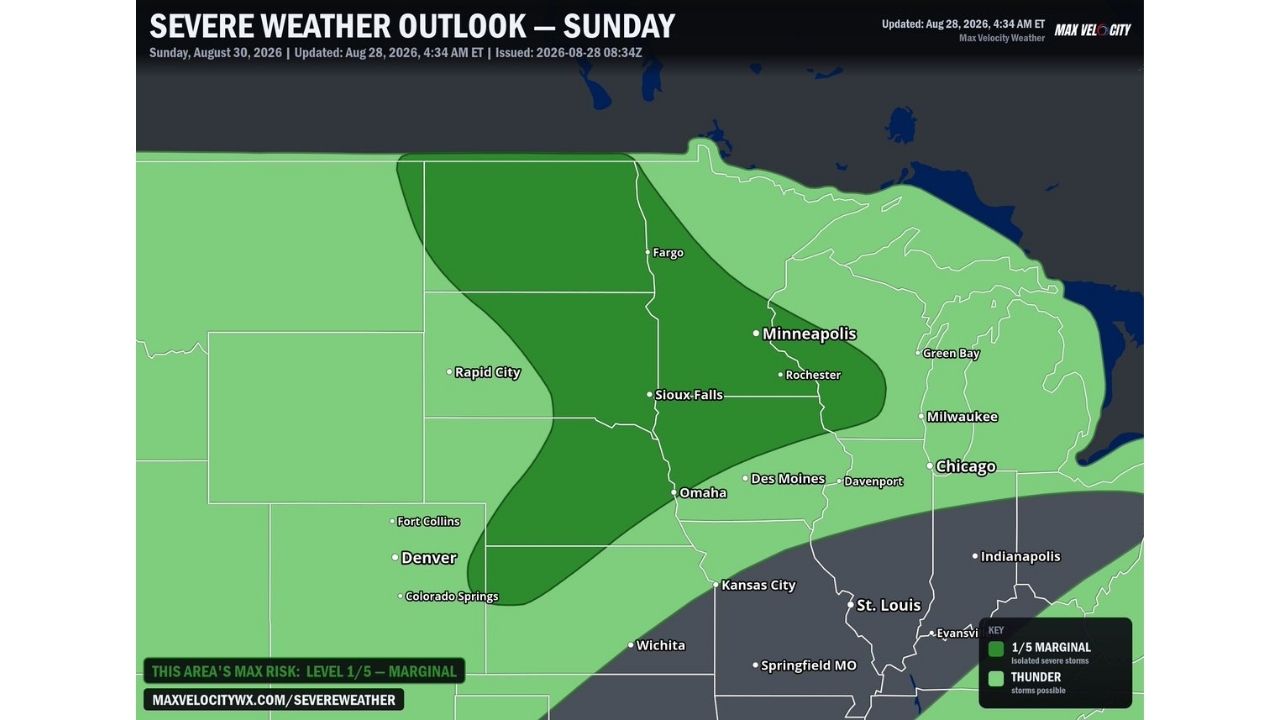
WAUSAU — Forecasters are monitoring for strong to severe storms across central Wisconsin on Sunday afternoon and evening, August 30, with a low-end risk zone stretching from near Wausau and Green Bay through Madison and La Crosse. A few storms capable of producing damaging wind gusts and hail will be possible, though forecasters caution the exact placement could still shift east or west as the weekend approaches.

Green Bay to La Crosse Sit in the Crosshairs of Sunday’s Low-End Risk

The risk map places central and eastern Wisconsin, including Wausau, Green Bay, Madison, Milwaukee, and La Crosse, under a low-end designation for Sunday, August 30, the lowest tier on a five-level scale that also includes possible, likely, and highly likely categories. No part of the outlined map currently reaches those higher tiers, keeping Sunday’s threat contained to the low end of the risk spectrum for now.

Why Forecasters Are Flagging This Days in Advance Despite the Low-End Label

Even a low-end designation gets flagged this early because forecasters want residents watching for slight shifts west or east as more data comes in closer to Sunday. The core hazards, damaging wind gusts and large hail, are still on the table for any storms that do fire, meaning the low-end label reflects uncertainty in coverage and placement more than a guarantee of weak storms. As the event draws closer, forecasters expect to refine exactly which communities fall inside the highest-confidence zone.

Sunday’s Storms Remain Two Days Out With Placement Still in Flux

This is an early outlook for a weekend threat that hasn’t yet developed, and the risk area itself is subject to shift as Sunday approaches. No watches, warnings, or damage reports currently exist for this event. This article will be updated as forecasters refine the risk zone and if storms develop Sunday afternoon or evening.

Getting Ready as Central Wisconsin Watches the Weekend Forecast

In the days leading up to Sunday:

  • Check back for updated risk maps, since forecasters expect the zone to shift east or west with more data
  • Have a way to receive warnings ready, a weather radio or phone alerts, ahead of Sunday afternoon
  • Secure loose outdoor items as Sunday approaches, given the damaging wind gust potential

If storms develop Sunday:

  • Move indoors immediately if a warning is issued for your area
  • Stay away from windows during hail or high wind

After storms pass:

  • Check for hail and wind damage to vehicles and property
  • Avoid downed power lines and treat all as live

A Weekend Threat Still Finding Its Final Shape

With central Wisconsin currently sitting under the map’s lowest risk tier and forecasters explicitly warning that shifts are still likely, Sunday’s severe weather setup remains a moving target, one worth watching closely as the weekend draws nearer and the exact placement of any damaging storms comes into sharper focus.
Featured Articles

  • Damaging Wind Gusts and Hail Loom Over Central Wisconsin as Forecasters Lock In on Sunday Evening Storm Threat

    Damaging Wind Gusts and Hail Loom Over Central Wisconsin as Forecasters Lock In on Sunday Evening Storm Threat

    August 28, 2026
  • Isolated Wind and Hail Threat Stretches 700 Miles From Fargo to Denver as Storms Eye Sunday Breakthrough

    Isolated Wind and Hail Threat Stretches 700 Miles From Fargo to Denver as Storms Eye Sunday Breakthrough

    August 28, 2026
  • Explosive Rain Bomb Set to Drench Minnesota and Western Wisconsin as Powerful Jet Dynamics Collide Saturday

    Explosive Rain Bomb Set to Drench Minnesota and Western Wisconsin as Powerful Jet Dynamics Collide Saturday

    August 28, 2026
  • Oppressive 79 Degree Dew Points Set to Blanket Eastern US as Miserable Moisture Surge Targets Millions Next Week

    Oppressive 79 Degree Dew Points Set to Blanket Eastern US as Miserable Moisture Surge Targets Millions Next Week

    August 28, 2026
  • 75 MPH Hurricane Force Winds Set to Slam Salt Lake City and Rapid City Saturday in Explosive Two State Threat

    75 MPH Hurricane Force Winds Set to Slam Salt Lake City and Rapid City Saturday in Explosive Two State Threat

    August 28, 2026

Search

Follow Us on

  • Facebook
  • X
  • Instagram
  • VK
  • Pinterest
  • Last.fm
  • TikTok
  • Telegram
  • WhatsApp
  • RSS Feed

Categories

  • Forecast (58)

About Us

dulaneygriffin

Dulaney Griffin tracks storms, tornado risk, heat and snow across the United States, using National Weather Service and NOAA data. For active warnings in your area, always follow the National Weather Service and your local emergency officials.

Latest Articles

  • Damaging Wind Gusts and Hail Loom Over Central Wisconsin as Forecasters Lock In on Sunday Evening Storm Threat

    Damaging Wind Gusts and Hail Loom Over Central Wisconsin as Forecasters Lock In on Sunday Evening Storm Threat

    August 28, 2026
  • Isolated Wind and Hail Threat Stretches 700 Miles From Fargo to Denver as Storms Eye Sunday Breakthrough

    Isolated Wind and Hail Threat Stretches 700 Miles From Fargo to Denver as Storms Eye Sunday Breakthrough

    August 28, 2026
  • Explosive Rain Bomb Set to Drench Minnesota and Western Wisconsin as Powerful Jet Dynamics Collide Saturday

    Explosive Rain Bomb Set to Drench Minnesota and Western Wisconsin as Powerful Jet Dynamics Collide Saturday

    August 28, 2026

Categories

  • Forecast (58)
  • Instagram
  • Facebook
  • LinkedIn
  • X
  • VK
  • TikTok

Proudly Powered by WordPress | JetNews Magazine by CozyThemes.

Scroll to Top