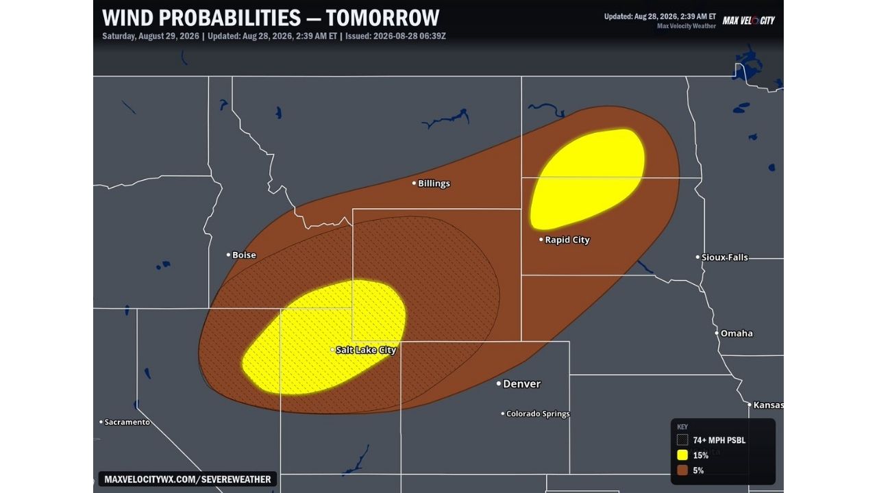
SALT LAKE CITY — Salt Lake City and surrounding areas could see severe storms tomorrow, Saturday, August 29, bringing the potential for 75 mph wind gusts, hurricane force intensity, according to the latest wind probability outlook issued at 2:39 a.m. ET. A second, separated risk zone carrying the same threat is also centered near Rapid City, roughly 500 miles to the northeast.
Two Separate Bullseyes Emerge Across the Northern Rockies and Plains
The outlook highlights two distinct 15% probability zones for gusts exceeding 74 mph, one centered directly over Salt Lake City, the other over Rapid City. Both sit inside a broader 5% probability corridor that stretches from eastern Idaho and Nevada through Wyoming and Montana and into South Dakota, also placing Boise, Billings, and Sioux Falls within reach of the same destructive wind potential Saturday.
Why 75 MPH Gusts Put This Squarely in Hurricane Territory
Wind gusts of 75 mph cross the official threshold for hurricane-force winds, matching the strength of a Category 1 hurricane. When thunderstorm complexes produce gusts at that intensity, the resulting damage often mirrors what’s seen from a landfalling tropical system: snapped power poles, toppled trees, and roof damage, concentrated instead into a fast-moving, narrow corridor rather than a sprawling hurricane wind field. The fact that two separate metro areas, Salt Lake City and Rapid City, both carry the same 15% probability underscores just how widespread the ingredients for destructive wind are shaping up to be Saturday.
Saturday’s Storms Are Still a Day Away From Forming
As of this writing, Saturday’s severe weather has not yet developed, and this outlook reflects a forecast risk rather than confirmed storm activity. No wind reports or damage have been confirmed. This article will be updated as storms move through both zones Saturday and if damage reports come in.
Bracing for Destructive Winds in Two States at Once
Before storms arrive Saturday:
- Secure or bring in loose outdoor items, gusts at this intensity can turn furniture and equipment into projectiles
- Move vehicles into a garage or away from trees if possible
- Identify your safe room now, an interior room on the lowest floor, away from windows
When a warning is issued:
- Move to shelter immediately, hurricane-force gusts can arrive with little additional lead time once a warning is issued
- Stay away from windows and exterior walls
After the storm passes:
- Avoid downed power lines and treat all as live
- Watch for structural damage to roofs and outbuildings before reentering damaged structures
Nearly 500 Miles Apart, Same Destructive Threat
Saturday’s setup ties together two metro areas separated by hundreds of miles, Salt Lake City in the Great Basin and Rapid City on the northern Plains, under the same hurricane-force wind potential. The distance between the two bullseyes highlights just how expansive the atmospheric setup driving this threat has become heading into the weekend.
For more coverage like this, check back for the latest severe weather updates.