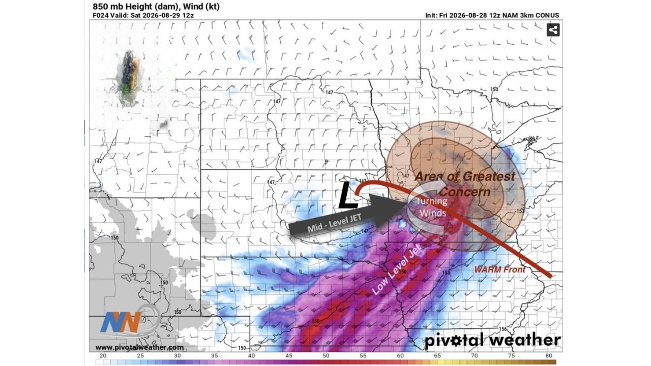
MINNEAPOLIS — The stage is set for widespread, significant rain across much of Minnesota and western Wisconsin on Saturday morning, August 29, as turning winds near a warm front combine with a mid-level jet and low-level jet to create powerful dynamics for a large thunderstorm complex. Forecasters have flagged an area of greatest concern centered near the Minnesota-Wisconsin border, where those turning winds intersect the approaching front.
Turning Winds Near a Warm Front Set the Stage for a Major Rain Producer
The setup driving Saturday’s rain hinges on a specific atmospheric ingredient: turning winds in the atmosphere near a warm front, a combination forecasters say produces excellent dynamics for supporting a large, organized thunderstorm complex rather than scattered, disorganized showers. A mid-level jet is shown feeding directly into that turning-wind zone, while a separate low-level jet stretches across a broad area of Minnesota, Iowa, and Wisconsin, pumping in the moisture that will fuel the heaviest rainfall.
Why This Setup Points to Widespread, Not Isolated, Rainfall
When turning winds near a warm front intersect with both a mid-level and low-level jet, as depicted in this forecast model, the result tends to be a large, organized storm complex capable of producing rain across a wide area rather than isolated downpours. The area of greatest concern, positioned over the Minnesota-Wisconsin border, marks where forecasters expect this dynamic to be most pronounced, and where the heaviest, most widespread rain is most likely to fall Saturday morning.
Saturday Morning’s Setup Is Still Taking Shape
This is a forecast model projection for a system that has not yet developed, valid for Saturday, August 29 at 12z. No rainfall totals, flooding, or storm reports have been confirmed as of this writing. This article will be updated as the system moves through Saturday morning and if rainfall or flooding impacts are confirmed.
Preparing for a Soggy Saturday Morning
Before the rain arrives:
- Check your Saturday morning plans, widespread rain is expected to move through during that window
- Clear gutters and storm drains ahead of potentially heavy rainfall rates
- Have a way to receive weather alerts, in case the complex produces stronger impacts than currently forecast
As the storm complex moves through:
- Avoid driving through low-lying or flood-prone roads if rainfall becomes heavy
- Watch for ponding on highways, especially where rain rates are heaviest near the area of greatest concern
After the system passes:
- Check local waterways and low-lying areas for any lingering flooding
- Monitor updated forecasts as the system’s actual track and intensity become clearer
A Textbook Setup Forecasters Are Watching Closely
The alignment of turning winds, a warm front, and dual-level jet dynamics is the kind of setup meteorologists watch for when anticipating a significant rain event, and its emergence heading into Saturday has forecasters flagging the Minnesota-Wisconsin border area as the likely epicenter of the heaviest rainfall as the weekend gets underway.
For more coverage like this, check back for the latest severe weather updates.