Skip to content

Home

About Us

Advertisement

Contact Us

  • Facebook
  • X
  • Instagram
  • Pinterest
  • WhatsApp
  • RSS Feed
  • TikTok

Dulaney Griffin

Your Trusted Weather Tracker.

Search

Heat Index Soars Past 100 Degrees Across Southern Pennsylvania as Long-Track Damaging Wind Threat Looms to the North

Melissa Peel Avatar
Melissa Peel
August 30, 2026
Heat Index Soars Past 100 Degrees Across Southern Pennsylvania as Long-Track Damaging Wind Threat Looms to the North

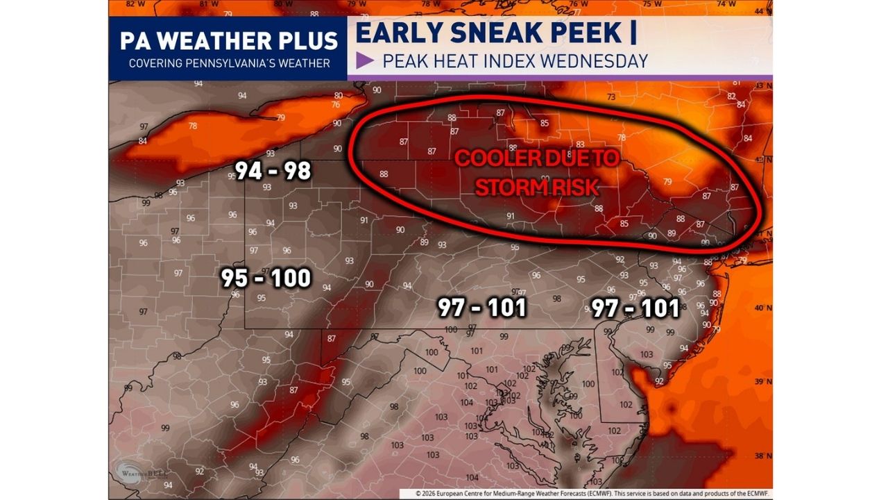
HARRISBURG — A dangerous heat wave is set to peak Wednesday, with heat index values climbing into the 95 to 100 degree range across southern Pennsylvania and reaching as high as 97 to 101 degrees across southern New Jersey and Delaware, while a separate storm threat targets the northern part of the state the same week.

A ridge of high pressure building across the Ohio Valley and Mid-Atlantic is driving the heat, with dew points climbing toward 70 degrees to add tropical-level humidity on top of the rising temperatures. It has been several weeks since heat index values reached this level in the region.

Where the Heat Hits Hardest

  • Southern Pennsylvania: Heat index values of 95 to 100 degrees, among the highest in the region
  • Southern New Jersey and Delaware: Heat index readings of 97 to 101 degrees
  • Northern Pennsylvania, along and north of I-80: Slightly cooler, in the 87 to 91 degree range, due to storm-related cloud cover
  • Peak timing: Heat index values expected to peak Wednesday

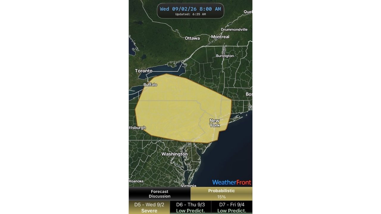
The area along and north of I-80 will see a break from the worst of the heat, but not from hazardous weather. Multiple storm clusters are expected to move through that stretch of Pennsylvania between Tuesday and Thursday, and forecasters say the combination of high heat, humidity and elevated wind shear could allow those clusters to produce long-track damaging wind segments.

A Two-Sided Weather Week Taking Shape

Southern Pennsylvania residents should prepare for prolonged heat exposure risks, while those farther north near I-80 face a different hazard entirely as storm season activity ramps up midweek. Anyone spending extended time outdoors in the hotter zones should take precautions given how high the heat index values are trending.

No heat-related illnesses or storm damage have been confirmed yet. This article will be updated as the heat wave and storm threat develop through the week.

Heat Safety Reminders

  • Before: Check on elderly neighbors and pets, and plan outdoor activities for early morning or evening
  • During peak heat: Stay hydrated, take frequent breaks in air conditioning, and watch for signs of heat exhaustion
  • After exposure: Seek shade or cooling immediately if experiencing dizziness, heavy sweating or nausea

For more coverage like this, check back for the latest severe weather updates.
Featured Articles

  • Scattered Storms Track Across Milwaukee and Northern Illinois Sunday as Wet Pattern Soaks the Ohio Valley

    Scattered Storms Track Across Milwaukee and Northern Illinois Sunday as Wet Pattern Soaks the Ohio Valley

    August 30, 2026
  • Rare Day 5 Severe Outlook Puts Buffalo and New York Under 15% Storm Threat as Multi-Day Setup Builds Through Friday

    Rare Day 5 Severe Outlook Puts Buffalo and New York Under 15% Storm Threat as Multi-Day Setup Builds Through Friday

    August 30, 2026
  • Marginal Risk Stretches From Kansas to Michigan and Minnesota as SPC Flags Monday-Tuesday Severe Setup Across the Corn Belt

    Marginal Risk Stretches From Kansas to Michigan and Minnesota as SPC Flags Monday-Tuesday Severe Setup Across the Corn Belt

    August 30, 2026
  • Evolving Supercells Threaten 80 MPH Wind Gusts and Golf Ball Hail Across Utah-Nevada Border as Watch Odds Hit 40%

    Evolving Supercells Threaten 80 MPH Wind Gusts and Golf Ball Hail Across Utah-Nevada Border as Watch Odds Hit 40%

    August 30, 2026
  • Marginal Risk Stretches From Kansas to Michigan as SPC Flags Monday-Tuesday Severe Setup Across the Corn Belt

    Marginal Risk Stretches From Kansas to Michigan as SPC Flags Monday-Tuesday Severe Setup Across the Corn Belt

    August 30, 2026

Search

Follow Us on

  • Facebook
  • X
  • Instagram
  • VK
  • Pinterest
  • Last.fm
  • TikTok
  • Telegram
  • WhatsApp
  • RSS Feed

Categories

  • Forecast (68)

About Us

dulaneygriffin

Dulaney Griffin tracks storms, tornado risk, heat and snow across the United States, using National Weather Service and NOAA data. For active warnings in your area, always follow the National Weather Service and your local emergency officials.

Latest Articles

  • Scattered Storms Track Across Milwaukee and Northern Illinois Sunday as Wet Pattern Soaks the Ohio Valley

    Scattered Storms Track Across Milwaukee and Northern Illinois Sunday as Wet Pattern Soaks the Ohio Valley

    August 30, 2026
  • Rare Day 5 Severe Outlook Puts Buffalo and New York Under 15% Storm Threat as Multi-Day Setup Builds Through Friday

    Rare Day 5 Severe Outlook Puts Buffalo and New York Under 15% Storm Threat as Multi-Day Setup Builds Through Friday

    August 30, 2026
  • Marginal Risk Stretches From Kansas to Michigan and Minnesota as SPC Flags Monday-Tuesday Severe Setup Across the Corn Belt

    Marginal Risk Stretches From Kansas to Michigan and Minnesota as SPC Flags Monday-Tuesday Severe Setup Across the Corn Belt

    August 30, 2026

Categories

  • Forecast (68)
  • Instagram
  • Facebook
  • LinkedIn
  • X
  • VK
  • TikTok

Proudly Powered by WordPress | JetNews Magazine by CozyThemes.

Scroll to Top