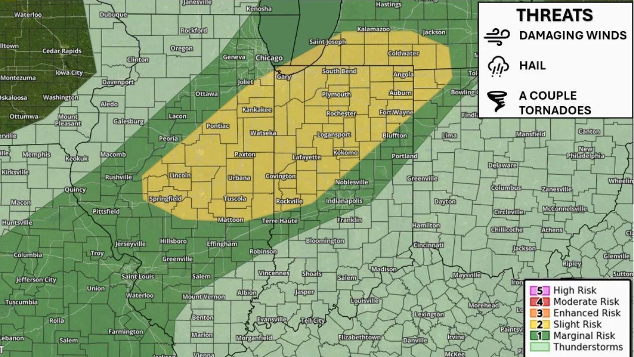
SOUTH BEND — A Slight Risk (Level 2 of 5) for severe weather is in place for Wednesday, August 26, across eastern Illinois, west-central and northern Indiana, and southern Michigan, with forecasters warning of damaging wind gusts, large hail, and a couple of tornadoes as storms develop and move through the region. Cities within the outlined risk zone include South Bend, Fort Wayne, Kokomo, Lafayette, and Kalamazoo.
What Wednesday’s Outlook Covers
- Risk level: Slight Risk (Level 2 of 5)
- Coverage area: eastern Illinois, west-central and northern Indiana, southern Michigan, including South Bend, Fort Wayne, Kokomo, Lafayette, Plymouth, Angola, and Kalamazoo
- Primary threats: damaging wind gusts and large hail
- Secondary threat: a couple of tornadoes possible
- Timing: storms developing and moving through the region Wednesday, with the greatest risk during the afternoon and evening hours
Why This Setup Matters
A Slight Risk designation means forecasters expect scattered severe thunderstorms are likely across the highlighted zone, storms capable of producing damaging winds and large hail, with a lower-end but real chance of an isolated tornado. Forecasters are emphasizing that conditions can change quickly through the afternoon and evening as storms organize and move across Illinois, Indiana, and Michigan, meaning the situation could evolve rapidly once initiation begins.
Where Things Stand
Wednesday’s storms have not yet developed as of this writing, and this outlook reflects a forecast risk rather than a confirmed severe weather event. No watches, warnings, or damage reports currently exist. This article will be updated as the threat develops and if watches or warnings are issued Wednesday.
Severe Weather Safety Guide
Before storms arrive Wednesday:
- Stay weather-aware through the afternoon and evening, when conditions are expected to change quickly
- Identify your safe room now: an interior room on the lowest floor, away from windows
- Have a way to receive warnings: a weather radio or phone alerts
When a warning is issued:
- Move to shelter immediately if a tornado or severe thunderstorm warning is issued for your area
- Stay away from windows during high wind or hail
After storms pass:
- Check for hail damage to vehicles and roofing
- Avoid downed power lines and treat all as live
A Multi-State Severe Threat Taking Shape
Wednesday’s Slight Risk stretches across three states, from eastern Illinois through northern Indiana and into southern Michigan, as forecasters track a system capable of producing organized severe storms across the region. With damaging wind and large hail identified as the top concerns and an isolated tornado risk layered in, communities across the corridor are being encouraged to monitor conditions closely as the afternoon progresses.
For more coverage like this, check back for the latest severe weather updates.