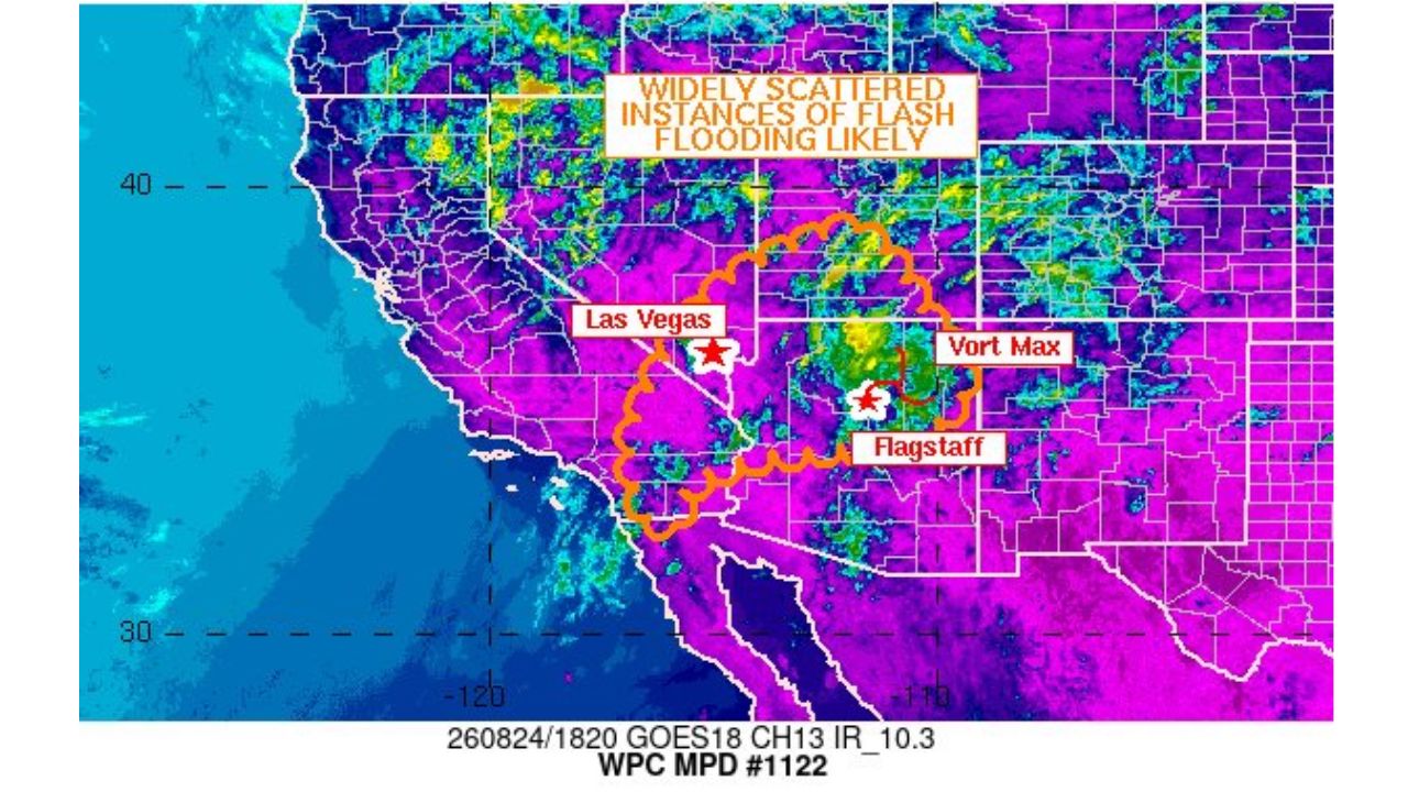
FLAGSTAFF — The Weather Prediction Center issued Mesoscale Discussion #1122 for a broad stretch of the Southwest, warning that widely scattered instances of flash flooding are likely across parts of Nevada, Utah, Arizona, and California as heavy rain-producing storms move through the region. The highlighted zone stretches from near Las Vegas eastward to Flagstaff, with a vorticity maximum identified over northern Arizona driving the heaviest rainfall potential.
What the Discussion Covers
- Affected area: portions of Nevada, Utah, Arizona, and California, centered on a corridor between Las Vegas and Flagstaff
- Primary concern: widely scattered instances of flash flooding
- Driving feature: a vorticity maximum located over northern Arizona, near Flagstaff
- Product type: WPC Mesoscale Precipitation Discussion
Why This Discussion Matters
A Mesoscale Precipitation Discussion is issued when forecasters identify a specific atmospheric feature, in this case a vorticity maximum, that’s expected to enhance rainfall rates enough to raise flash flood concerns beyond what a routine forecast would suggest. Satellite imagery shows widespread moisture and thunderstorm activity across the region, with the strongest, most organized rainfall concentrated near the identified vort max over northern Arizona. Because flash flooding can develop quickly and with little warning in desert terrain, where soils don’t absorb heavy rain efficiently and dry washes can fill rapidly, this kind of targeted discussion gives residents and emergency managers an early heads-up before flood watches or warnings are issued.
Where Things Stand
As of this writing, this is a forecast discussion rather than a confirmed flash flood watch or warning, and no flooding has been confirmed across the highlighted area. This article will be updated if the National Weather Service issues flash flood watches or warnings, or if flooding is confirmed.
Flash Flood Safety Guide
Before storms arrive:
- Know if you’re in a flood-prone area, including near washes, canyons, or low-lying desert terrain
- Avoid planning travel through areas with a history of flash flooding
- Have a way to receive alerts, flash flooding can develop with little advance notice
If flash flooding develops:
- Never drive through flooded roadways, turn around, don’t drown, even in familiar areas
- Move to higher ground immediately if water begins rising nearby
- Stay out of desert washes and canyons during and after heavy rain
After the threat passes:
- Avoid walking or driving through standing water, it can hide debris or washed-out roads
- Check local flood warnings for continued rises even after rain ends
A Recurring Late-Summer Risk Across the Desert Southwest
This discussion adds to what has been a pattern of monsoon-driven flash flood concerns across the Southwest this season, with heavy rain repeatedly targeting the same general corridor between southern Nevada and northern Arizona. The combination of intense, localized rainfall and terrain prone to rapid runoff continues to make flash flooding one of the region’s more persistent late-summer hazards.
For more coverage like this, check back for the latest severe weather updates.