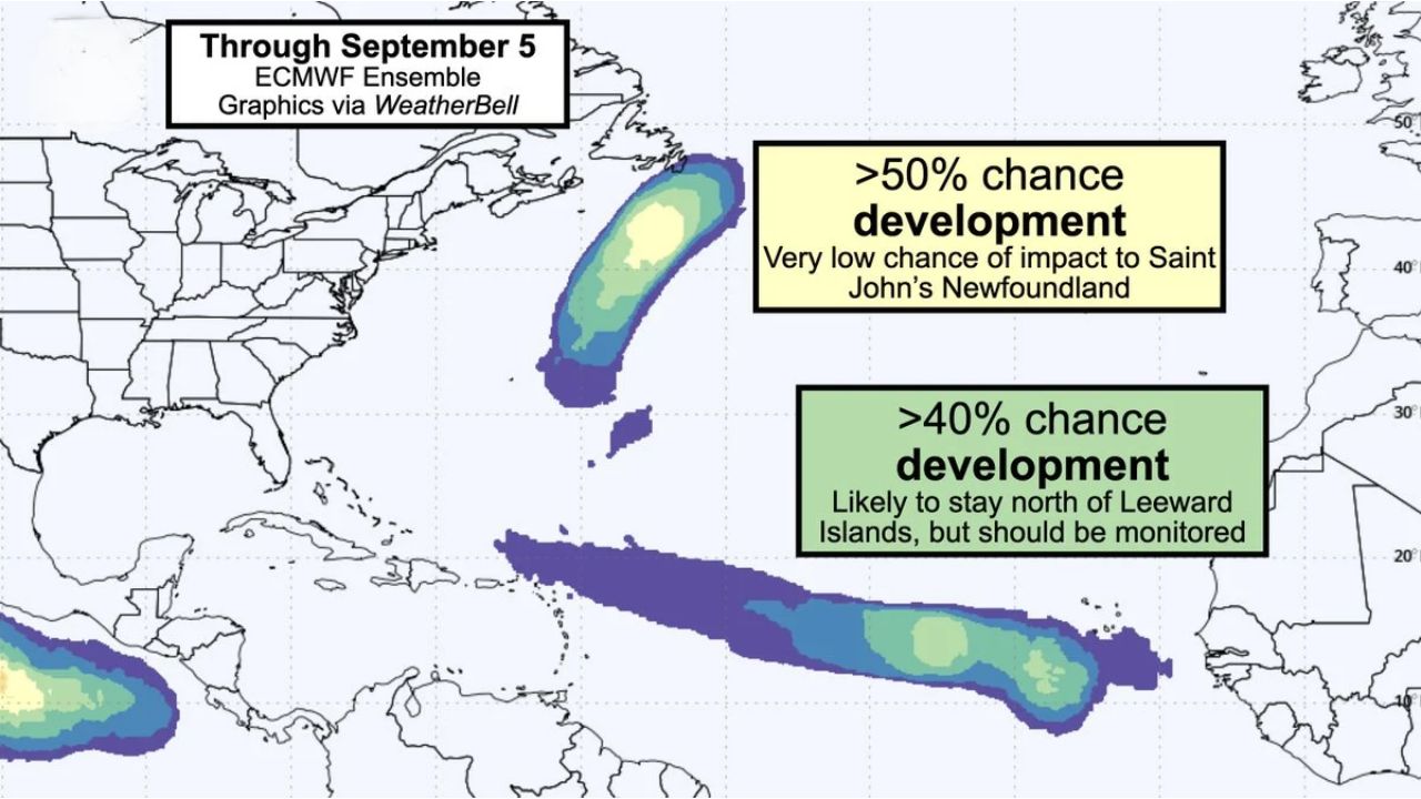
BERMUDA — Forecasters are tracking two separate tropical disturbances across the Atlantic as peak hurricane season continues, with development chances through September 5 running greater than 50% for a system north of Bermuda and greater than 40% for a second disturbance in the central Atlantic’s Main Development Region, southwest of the Cabo Verde Islands.
What the Two Systems Look Like
- System 1 (north of Bermuda): elongated and broad, currently lacking a well-defined center; could become a short-lived, weak tropical system lasting a day or two if thunderstorms develop near its ragged center over the Gulf Stream. Development chance is listed at greater than 50% through September 5, with a very low chance of impact to St. John’s, Newfoundland
- System 2 (central Atlantic, southwest of Cabo Verde Islands): a tropical wave producing showers and thunderstorms, but currently disorganized, not yet even a tropical depression, due to harsh upper-level winds displacing thunderstorm activity away from its low-level center. Development chance is listed at greater than 40% through September 5, and the system is expected to likely stay north of the Leeward Islands, though interests in the Lesser Antilles are advised to monitor it
Why Upper-Level Winds Are Limiting Development
Strong upper-level winds, a hallmark of El Niño seasons, are shredding apart several borderline systems this year, a pattern forecasters point to as a key reason the Atlantic season has been running below average so far. In the case of the Cabo Verde disturbance, those harsh upper-level winds are blowing showers and thunderstorms south and west of the disorganized low-level center, keeping the system lopsided and weak for now, even as it shows signs of looking “healthier” than in recent days.
Where Things Stand
Neither system has organized into a tropical depression or named storm as of this writing. Both remain under watch as disturbances with development potential rather than confirmed tropical cyclones. This article will be updated if either system strengthens or if the National Hurricane Center issues formal advisories.
Tropical Season Preparedness Guide
For the Lesser Antilles and Leeward Islands:
- Monitor the central Atlantic disturbance closely, even though it’s currently expected to track north of the islands
- Review your hurricane plan now, before any system requires more urgent attention
For Bermuda and the western Atlantic:
- Track the Bermuda-area system’s development, since short-lived subtropical or tropical systems can still bring rough surf and localized impacts even without a direct landfall
General peak-season readiness:
- Keep an eye on the tropics through early September, historically the most active stretch of hurricane season
- Have a hurricane kit ready regardless of current storm tracks, since peak season can produce rapid changes
A Quieter Season, But Not a Quiet Atlantic
Even with El Niño-driven wind shear keeping this season’s storm count below average, the Atlantic remains far from empty, with two systems now being watched simultaneously across very different parts of the basin. Whether either disturbance organizes into the season’s next named storm will depend largely on whether they can find enough separation from the disruptive upper-level winds currently working against them.
For more coverage like this, check back for the latest severe weather updates.