Skip to content

Home

About Us

Advertisement

Contact Us

  • Facebook
  • X
  • Instagram
  • Pinterest
  • WhatsApp
  • RSS Feed
  • TikTok

Dulaney Griffin

Your Trusted Weather Tracker.

Search

Damaging Wind, Hail and Tornado Threat Sweeps From Buffalo to Philadelphia and Boston Wednesday as 15% Severe Risk Zone Expands Across New York and New England

Melissa Peel Avatar
Melissa Peel
August 30, 2026
Damaging Wind, Hail and Tornado Threat Sweeps From Buffalo to Philadelphia and Boston Wednesday as 15% Severe Risk Zone Expands Across New York and New England

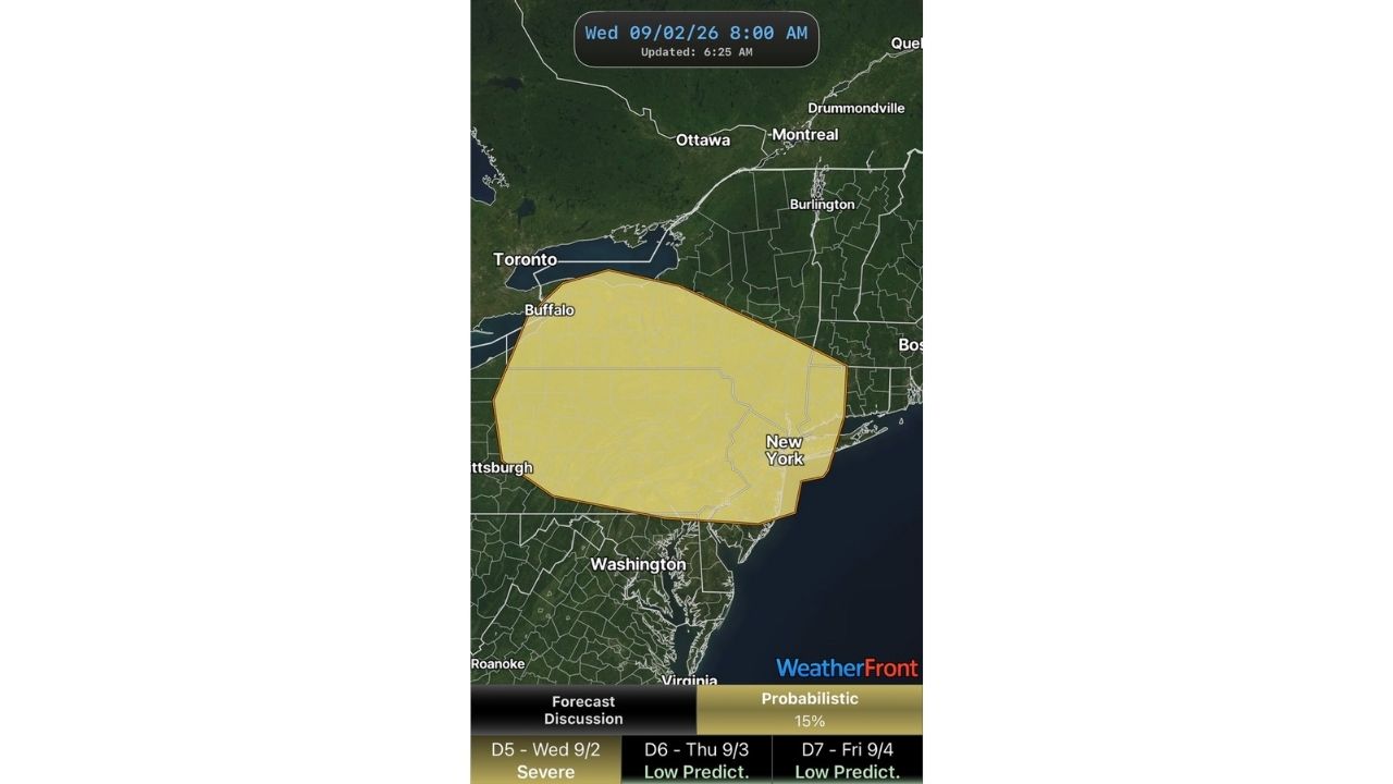
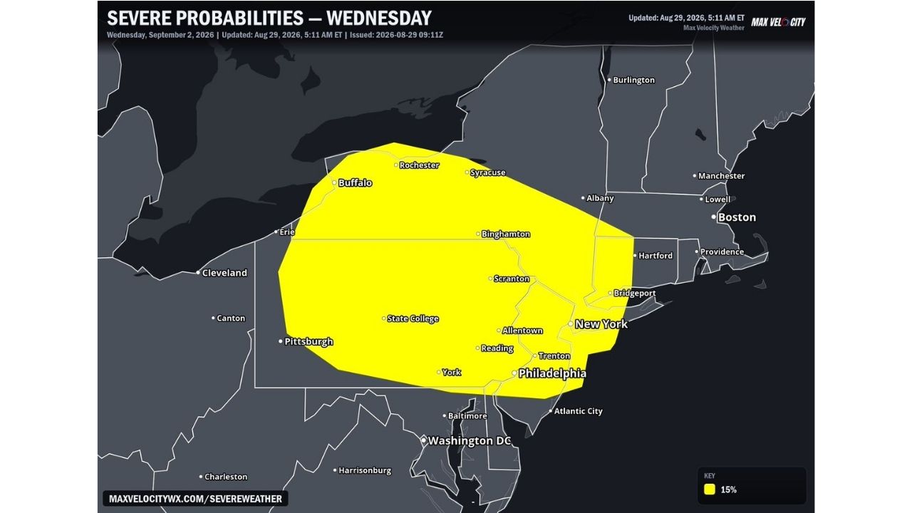
PHILADELPHIA — A broad 15% severe risk zone stretches from Buffalo and Rochester through Scranton, Allentown, Philadelphia, Hartford and into the outskirts of Boston for Wednesday, September 2, as forecasters track a developing severe weather setup across the Northeast.

The threat is being fueled by a mid-level disturbance rounding a persistent upper-level ridge, which is expected to push into a warm, moist air mass already in place across the region. Combined with favorable wind shear, that combination is enough to spark strong to severe thunderstorms stretching from southern New England down through the Mid-Atlantic.

What’s In Play Wednesday

  • Coverage area: From Buffalo and Erie in the west to Boston, Providence and Bridgeport in the east
  • Southern extent: Includes Philadelphia, Trenton, Reading and York
  • Risk level: 15% probability of severe weather within 25 miles of any point
  • Timing: Threat develops Wednesday as the disturbance moves through
  • Hazards: All modes remain possible — damaging wind, large hail and an isolated tornado threat can’t be ruled out

Forecasters emphasize that confidence in the exact magnitude and location of the worst storms will sharpen as Wednesday approaches. Cities like New York, Binghamton, State College and Albany all sit inside the outlined zone and should monitor the forecast through the week.

A Setup Still Coming Into Focus

With several days still separating now from Wednesday, meteorologists caution that the placement and intensity of individual storm cells remain uncertain. Residents across the corridor from upstate New York through the Mid-Atlantic and into New England should stay weather-aware as updates refine the picture closer to game day.

No damage or impacts have occurred yet, as this is a forward-looking outlook. This article will be updated as the threat window approaches and new information becomes available.

For more coverage like this, check back for the latest severe weather updates.
Featured Articles

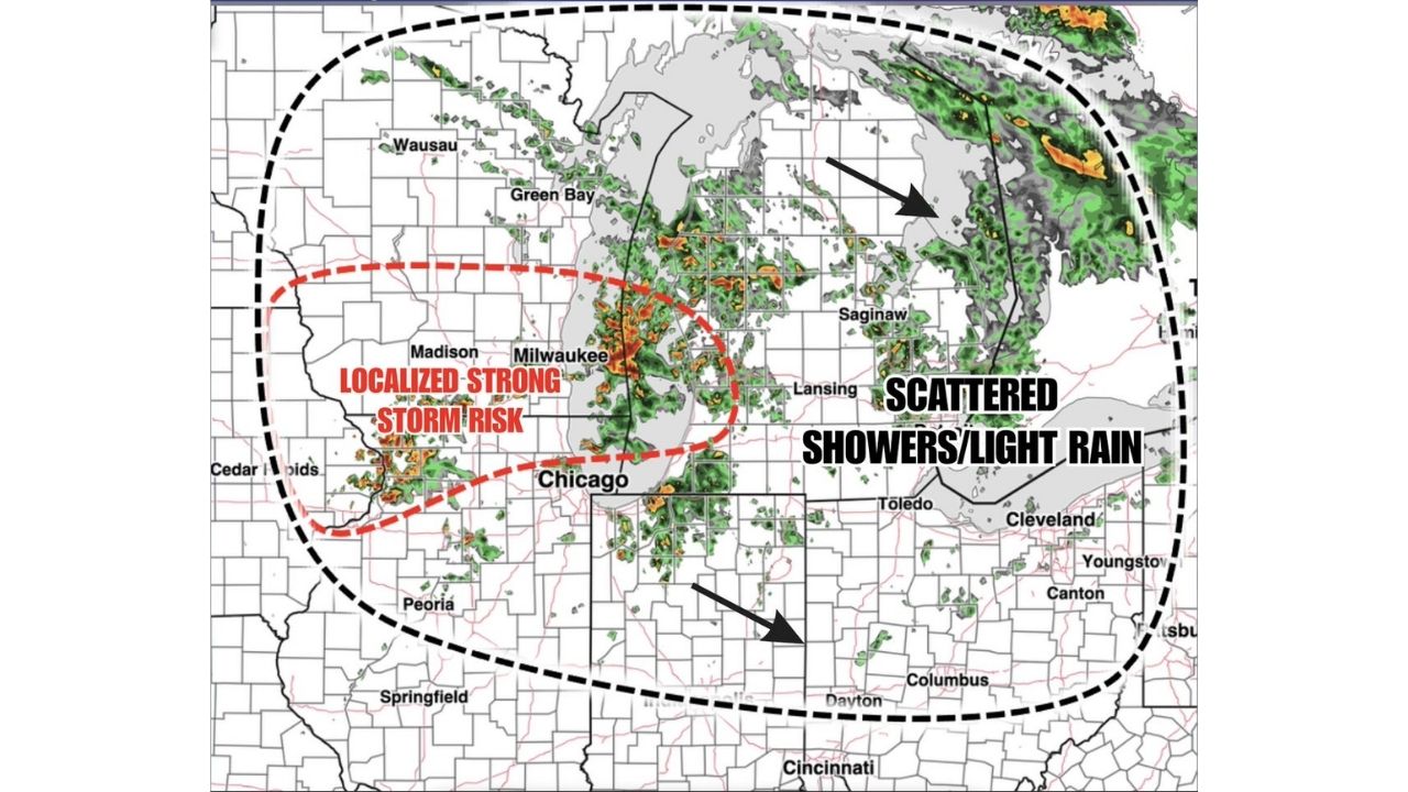
  • Scattered Storms Track Across Milwaukee and Northern Illinois Sunday as Wet Pattern Soaks the Ohio Valley

    Scattered Storms Track Across Milwaukee and Northern Illinois Sunday as Wet Pattern Soaks the Ohio Valley

    August 30, 2026
  • Rare Day 5 Severe Outlook Puts Buffalo and New York Under 15% Storm Threat as Multi-Day Setup Builds Through Friday

    Rare Day 5 Severe Outlook Puts Buffalo and New York Under 15% Storm Threat as Multi-Day Setup Builds Through Friday

    August 30, 2026
  • Marginal Risk Stretches From Kansas to Michigan and Minnesota as SPC Flags Monday-Tuesday Severe Setup Across the Corn Belt

    Marginal Risk Stretches From Kansas to Michigan and Minnesota as SPC Flags Monday-Tuesday Severe Setup Across the Corn Belt

    August 30, 2026
  • Evolving Supercells Threaten 80 MPH Wind Gusts and Golf Ball Hail Across Utah-Nevada Border as Watch Odds Hit 40%

    Evolving Supercells Threaten 80 MPH Wind Gusts and Golf Ball Hail Across Utah-Nevada Border as Watch Odds Hit 40%

    August 30, 2026
  • Marginal Risk Stretches From Kansas to Michigan as SPC Flags Monday-Tuesday Severe Setup Across the Corn Belt

    Marginal Risk Stretches From Kansas to Michigan as SPC Flags Monday-Tuesday Severe Setup Across the Corn Belt

    August 30, 2026

Search

Follow Us on

  • Facebook
  • X
  • Instagram
  • VK
  • Pinterest
  • Last.fm
  • TikTok
  • Telegram
  • WhatsApp
  • RSS Feed

Categories

  • Forecast (68)

About Us

dulaneygriffin

Dulaney Griffin tracks storms, tornado risk, heat and snow across the United States, using National Weather Service and NOAA data. For active warnings in your area, always follow the National Weather Service and your local emergency officials.

Latest Articles

  • Scattered Storms Track Across Milwaukee and Northern Illinois Sunday as Wet Pattern Soaks the Ohio Valley

    Scattered Storms Track Across Milwaukee and Northern Illinois Sunday as Wet Pattern Soaks the Ohio Valley

    August 30, 2026
  • Rare Day 5 Severe Outlook Puts Buffalo and New York Under 15% Storm Threat as Multi-Day Setup Builds Through Friday

    Rare Day 5 Severe Outlook Puts Buffalo and New York Under 15% Storm Threat as Multi-Day Setup Builds Through Friday

    August 30, 2026
  • Marginal Risk Stretches From Kansas to Michigan and Minnesota as SPC Flags Monday-Tuesday Severe Setup Across the Corn Belt

    Marginal Risk Stretches From Kansas to Michigan and Minnesota as SPC Flags Monday-Tuesday Severe Setup Across the Corn Belt

    August 30, 2026

Categories

  • Forecast (68)
  • Instagram
  • Facebook
  • LinkedIn
  • X
  • VK
  • TikTok

Proudly Powered by WordPress | JetNews Magazine by CozyThemes.

Scroll to Top