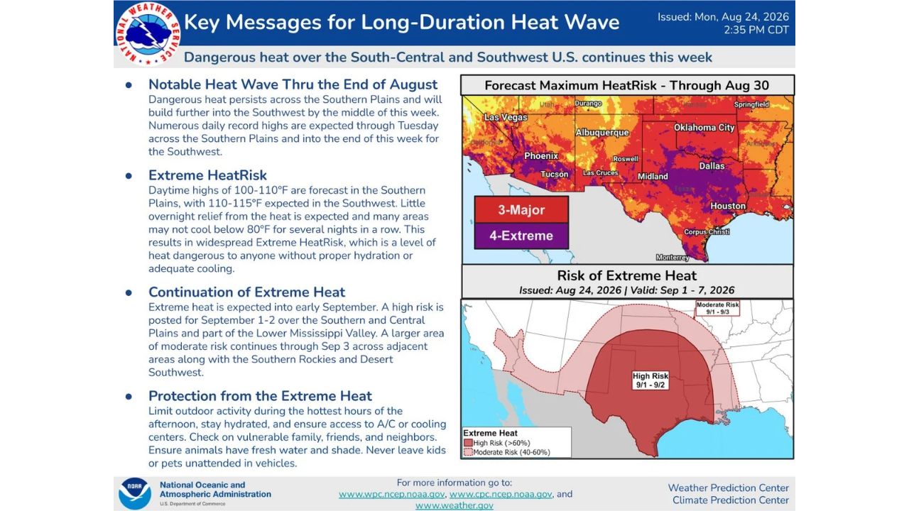
PHOENIX — A long-duration heat wave continues to grip the Southern Plains and is set to build further into the Southwest United States by midweek, with the National Weather Service warning of numerous daily record highs through Tuesday across the Southern Plains and continuing into the Southwest through the end of the week. Extreme HeatRisk conditions are forecast for major cities including Phoenix, Las Vegas, Tucson, Oklahoma City, Dallas, and Albuquerque.
What the Heat Outlook Covers
- Southern Plains highs: 100 to 110°F
- Southwest highs: 110 to 115°F
- Overnight lows: many areas may not drop below 80°F for several nights in a row
- HeatRisk level: widespread Extreme HeatRisk, dangerous to anyone without proper hydration or adequate cooling
- Forecast period: dangerous heat through August 30, with Extreme Heat continuing into early September
- High Risk designation: posted for September 1 to 2 across the Southern and Central Plains and part of the Lower Mississippi Valley
- Moderate Risk designation: extends through September 3 across the Southern Rockies and Desert Southwest
Why This Heat Wave Matters
An Extreme HeatRisk designation, the highest tier on the National Weather Service’s heat risk scale, means the heat poses a danger to anyone without proper hydration or access to cooling, not just vulnerable populations. With little overnight relief expected and lows staying near or above 80°F for consecutive nights, the body gets little chance to recover between hot afternoons, a pattern that significantly raises the risk of heat-related illness the longer it continues. The fact that this heat wave is forecast to persist into early September, rather than break by the end of August, adds to the danger given how long residents across the Southern Plains and Southwest will be under sustained heat stress.
Where Things Stand
This is an active, ongoing heat wave with daily record highs already occurring across the Southern Plains as of this week. No specific heat-related fatality or illness figures have been confirmed as part of this advisory. This article will be updated as the National Weather Service issues further heat products or if impacts are confirmed.
Extreme Heat Safety Guide
Before and during peak heat:
- Limit outdoor activity during the hottest hours of the afternoon
- Stay hydrated throughout the day, don’t wait until you feel thirsty
- Ensure access to A/C or cooling centers if your home lacks reliable air conditioning
Protecting others:
- Check on vulnerable family, friends, and neighbors, especially elderly residents
- Ensure animals have fresh water and shade
- Never leave kids or pets unattended in vehicles, even briefly
As the heat continues into September:
- Watch for updated NWS heat products as High and Moderate Risk designations extend into early September
- Plan for continued overnight heat, with lows staying near 80°F, indoor cooling remains critical even after sunset
A Heat Wave With No Clear End in Sight
Unlike shorter heat events, this pattern is forecast to persist for more than a week, with Extreme Heat Risk continuing from the Southern Plains into the Southwest through the end of August, then shifting into a High Risk designation for the Southern and Central Plains as the calendar turns to September. The sustained nature of this heat wave, rather than any single day’s temperature, is what’s driving the concern from forecasters.
For more coverage like this, check back for the latest severe weather updates.