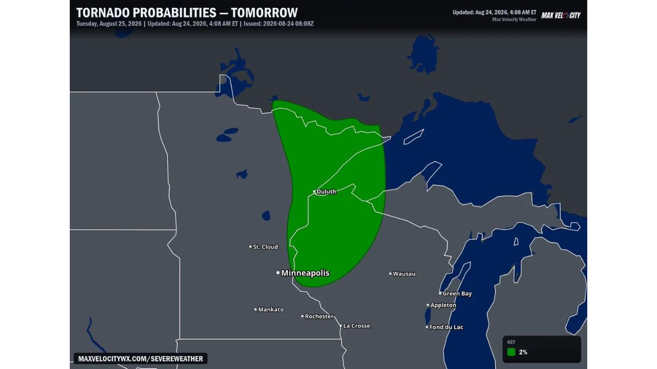
DULUTH — A low-end tornado threat has been outlined for Tuesday, August 25, across a stretch of northern Minnesota surrounding Duluth, with forecasters flagging a 2% tornado probability zone stretching south toward St. Cloud and near the outskirts of the Minneapolis metro. The tornado probability outlook was issued at 4:08 a.m. ET Monday, tied to severe weather expected to develop Tuesday.
What the Outlook Covers
- Tornado probability: 2%
- Valid date: Tuesday, August 25, 2026
- Coverage area: stretches from just south of the Canadian border through Duluth and down toward St. Cloud, at the edge of the Minneapolis metro
- Threat level: described as a low-end tornado threat
Why This Threat Level Matters
A 2% tornado probability is on the lower end of the scale forecasters use, but it’s still enough to warrant awareness for residents in the outlined zone, particularly since tornado risk of any level means residents should have a way to receive warnings if storms turn severe. Low-end doesn’t mean no threat, it signals that while widespread or intense tornado activity isn’t expected, an isolated tornado remains possible if storms organize as forecast Tuesday.
Where Things Stand
Tuesday’s severe weather has not yet developed as of this writing, and this outlook reflects a forecast risk rather than a confirmed tornado watch or warning. No damage or storm reports currently exist for this event. This article will be updated if the National Weather Service issues a tornado watch or warning, or if storm reports come in Tuesday.
Severe Weather Safety Guide
Before Tuesday’s storms arrive:
- Identify your safe room now: an interior room on the lowest floor, away from windows
- Charge phones and battery packs in case power is affected by associated severe weather
- Have a way to receive warnings overnight or during the day: a weather radio or phone alerts
If a tornado warning is issued:
- Move to your safe room immediately: don’t wait to see the storm
- Stay away from windows
- If caught outside or in a vehicle, seek the nearest sturdy shelter
After storms pass:
- Avoid downed power lines and treat all as live
- Check on neighbors, especially those without reliable transportation or shelter
Tuesday Adds to an Active Stretch for the Upper Midwest
This low-end tornado threat comes as part of a broader severe weather setup expected to move through the Upper Midwest Tuesday, with Duluth and the surrounding region positioned at the center of the outlined probability zone as forecasters continue to monitor how the severe weather threat evolves through the day.
For more coverage like this, visit Eye of the Hurricane News for the latest severe weather updates.