Skip to content

Home

About Us

Advertisement

Contact Us

  • Facebook
  • X
  • Instagram
  • Pinterest
  • WhatsApp
  • RSS Feed
  • TikTok

Dulaney Griffin

Your Trusted Weather Tracker.

Search

Extreme Heat Peaks Across the Carolinas and Georgia With Charleston Near 109 and Columbia Near 105 Before Much Cooler Air Arrives Monday

Melissa Peel Avatar
Melissa Peel
August 21, 2026
Extreme Heat Peaks Across the Carolinas and Georgia With Charleston Near 109 and Columbia Near 105 Before Much Cooler Air Arrives Monday

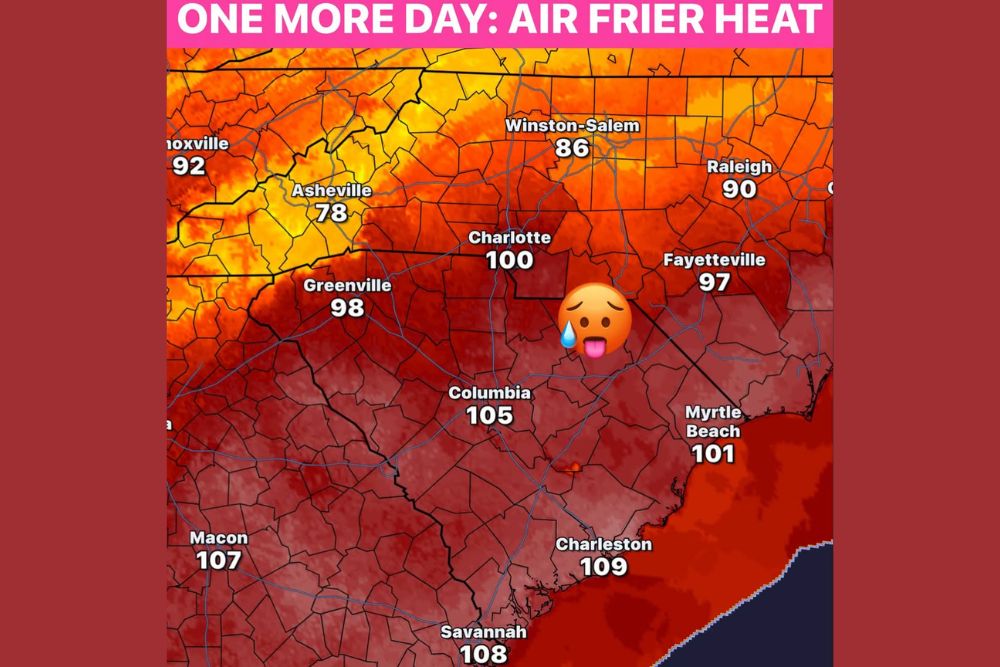
CAROLINAS AND GEORGIA — One more day of extreme heat index values is set to grip the region, with numbers still climbing into dangerous territory across the Carolinas and Georgia. Charleston is forecast to feel like 109 degrees, while Savannah and Macon are expected to reach 108 and 107 degrees, respectively. Tomorrow won’t be dramatically cooler, but humidity levels are expected to drop, offering some relief even before the bigger pattern change arrives.

Inland Cities Face Triple Digit Heat Index Values Today

Charlotte is forecast to feel like 100 degrees, while Greenville and Columbia climb even higher, to 98 and 105 degrees, respectively, as the heat index peaks across the interior.

Farther east, Fayetteville and Myrtle Beach are expected to reach 97 and 101 degrees, keeping dangerous heat in place across a wide swath of the region today.

Humidity Begins Easing Into the Weekend

Forecasters say conditions will begin improving Sunday into Monday, as humidity levels drop and the overall feel of the air becomes noticeably more comfortable across the region.

While tomorrow won’t bring an immediate cooldown, the drop in humidity is expected to make outdoor conditions more tolerable heading into the weekend.

A Big Pattern Change Brings 50s and 60s by Monday

The most significant shift arrives by Monday and Tuesday morning, when temperatures are forecast to fall into the 50s and 60s across parts of the region.

This marks a dramatic swing from the current heat index values well above 100 degrees, representing one of the more notable pattern changes of the season so far.


Featured Articles

  • Burns, Lakeview and Susanville Face Critical Fire Danger Saturday as 25 MPH Winds and 15 Percent Humidity Return to the Northwest

    Burns, Lakeview and Susanville Face Critical Fire Danger Saturday as 25 MPH Winds and 15 Percent Humidity Return to the Northwest

    August 21, 2026
  • Washington, Rockville and Baltimore Watch Sub-Severe Storm Line Approach as Warnings Possible Over Next Two Hours

    Washington, Rockville and Baltimore Watch Sub-Severe Storm Line Approach as Warnings Possible Over Next Two Hours

    August 21, 2026
  • Davenport to Milwaukee Face Quick Tornado Risk This Afternoon as Scattered Storms Develop Across Southern Wisconsin and Northern Illinois

    Davenport to Milwaukee Face Quick Tornado Risk This Afternoon as Scattered Storms Develop Across Southern Wisconsin and Northern Illinois

    August 21, 2026
  • Scattered Coastal Storms Develop Across North Carolina Including Jacksonville Wilmington and Central NC With Gusty Winds and Heavy Rainfall This Afternoon Evening

    Scattered Coastal Storms Develop Across North Carolina Including Jacksonville Wilmington and Central NC With Gusty Winds and Heavy Rainfall This Afternoon Evening

    August 21, 2026
  • Extreme Heat Warning Blankets Louisiana Along With Parts of Texas Arkansas and Mississippi as Dangerous Conditions Grip the Entire Gulf Coast Region

    Extreme Heat Warning Blankets Louisiana Along With Parts of Texas Arkansas and Mississippi as Dangerous Conditions Grip the Entire Gulf Coast Region

    August 21, 2026

Search

Follow Us on

  • Facebook
  • X
  • Instagram
  • VK
  • Pinterest
  • Last.fm
  • TikTok
  • Telegram
  • WhatsApp
  • RSS Feed

Categories

  • Forecast (8)

About Us

dulaneygriffin

Dulaney Griffin tracks storms, tornado risk, heat and snow across the United States, using National Weather Service and NOAA data. For active warnings in your area, always follow the National Weather Service and your local emergency officials.

Latest Articles

  • Burns, Lakeview and Susanville Face Critical Fire Danger Saturday as 25 MPH Winds and 15 Percent Humidity Return to the Northwest

    Burns, Lakeview and Susanville Face Critical Fire Danger Saturday as 25 MPH Winds and 15 Percent Humidity Return to the Northwest

    August 21, 2026
  • Washington, Rockville and Baltimore Watch Sub-Severe Storm Line Approach as Warnings Possible Over Next Two Hours

    Washington, Rockville and Baltimore Watch Sub-Severe Storm Line Approach as Warnings Possible Over Next Two Hours

    August 21, 2026
  • Davenport to Milwaukee Face Quick Tornado Risk This Afternoon as Scattered Storms Develop Across Southern Wisconsin and Northern Illinois

    Davenport to Milwaukee Face Quick Tornado Risk This Afternoon as Scattered Storms Develop Across Southern Wisconsin and Northern Illinois

    August 21, 2026

Categories

  • Forecast (8)
  • Instagram
  • Facebook
  • LinkedIn
  • X
  • VK
  • TikTok

Proudly Powered by WordPress | JetNews Magazine by CozyThemes.

Scroll to Top