Skip to content

Home

About Us

Advertisement

Contact Us

  • Facebook
  • X
  • Instagram
  • Pinterest
  • WhatsApp
  • RSS Feed
  • TikTok

Dulaney Griffin

Your Trusted Weather Tracker.

Search

Scattered Coastal Storms Develop Across North Carolina Including Jacksonville Wilmington and Central NC With Gusty Winds and Heavy Rainfall This Afternoon Evening

Melissa Peel Avatar
Melissa Peel
August 21, 2026
Scattered Coastal Storms Develop Across North Carolina Including Jacksonville Wilmington and Central NC With Gusty Winds and Heavy Rainfall This Afternoon Evening

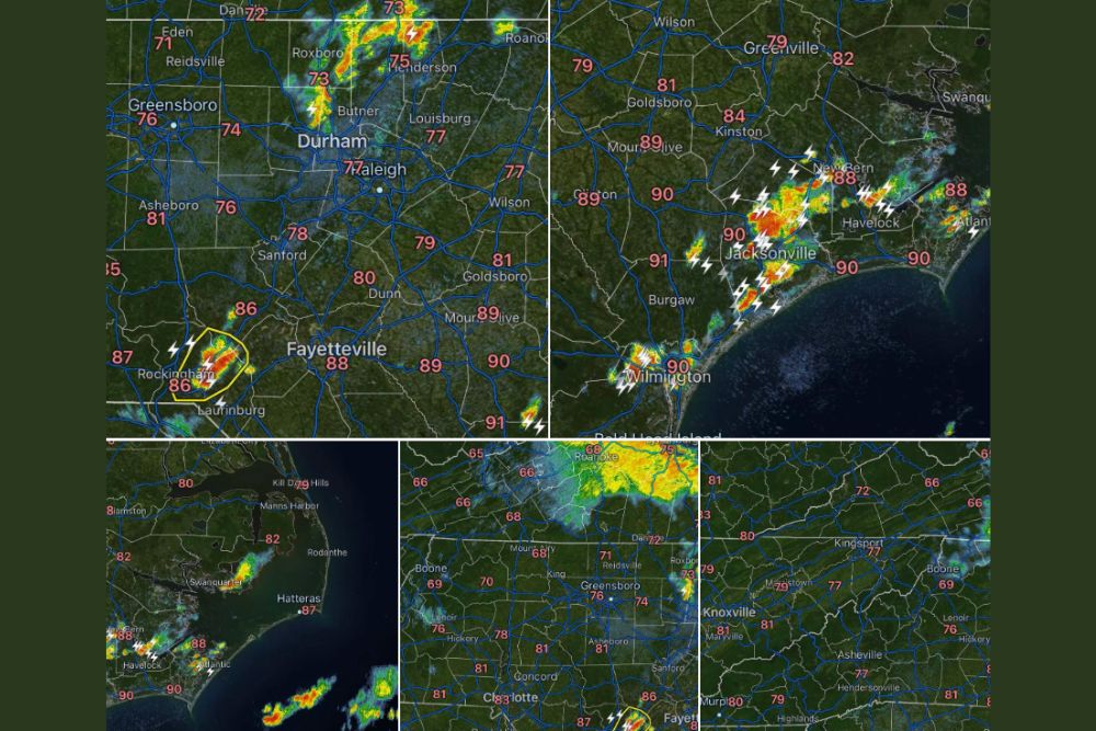
NORTH CAROLINA — Scattered showers and thunderstorms began developing along the coast Thursday early afternoon, with a couple of storms also forming across Central North Carolina. The developing storms are producing gusty winds and heavy rainfall, with the most intense activity so far concentrated near the coastline. Forecasters say they will continue monitoring conditions throughout the afternoon and evening as additional storms develop.

Coastal Corridor Sees the Most Active Storm Development

The heaviest storm activity as of 12:54 PM was concentrated along the coastal corridor near Jacksonville, New Bern, and Wilmington, with radar showing intense returns and frequent lightning strikes.

Temperatures across this zone were running into the upper 80s and low 90s, providing ample heat and instability to fuel the ongoing storm development along the coast.

A Few Storms Also Fire Across Central North Carolina

In addition to the coastal activity, a couple of storms developed near Rockingham and Laurinburg in south central North Carolina, with radar showing strong returns embedded within that cell.

Temperatures across the Triangle and Triad, including Durham, Raleigh, and Greensboro, remained in the mid to upper 70s as storms began organizing farther south and east.

Continued Monitoring Expected Through the Evening

Forecasters say they will keep residents posted throughout the afternoon and evening on any additional storm development, particularly if activity becomes more widespread or intense.

With gusty winds and heavy rainfall already occurring in isolated spots, residents across the state are encouraged to stay weather aware as the afternoon progresses.
Featured Articles

  • Burns, Lakeview and Susanville Face Critical Fire Danger Saturday as 25 MPH Winds and 15 Percent Humidity Return to the Northwest

    Burns, Lakeview and Susanville Face Critical Fire Danger Saturday as 25 MPH Winds and 15 Percent Humidity Return to the Northwest

    August 21, 2026
  • Washington, Rockville and Baltimore Watch Sub-Severe Storm Line Approach as Warnings Possible Over Next Two Hours

    Washington, Rockville and Baltimore Watch Sub-Severe Storm Line Approach as Warnings Possible Over Next Two Hours

    August 21, 2026
  • Davenport to Milwaukee Face Quick Tornado Risk This Afternoon as Scattered Storms Develop Across Southern Wisconsin and Northern Illinois

    Davenport to Milwaukee Face Quick Tornado Risk This Afternoon as Scattered Storms Develop Across Southern Wisconsin and Northern Illinois

    August 21, 2026
  • Scattered Coastal Storms Develop Across North Carolina Including Jacksonville Wilmington and Central NC With Gusty Winds and Heavy Rainfall This Afternoon Evening

    Scattered Coastal Storms Develop Across North Carolina Including Jacksonville Wilmington and Central NC With Gusty Winds and Heavy Rainfall This Afternoon Evening

    August 21, 2026
  • Extreme Heat Warning Blankets Louisiana Along With Parts of Texas Arkansas and Mississippi as Dangerous Conditions Grip the Entire Gulf Coast Region

    Extreme Heat Warning Blankets Louisiana Along With Parts of Texas Arkansas and Mississippi as Dangerous Conditions Grip the Entire Gulf Coast Region

    August 21, 2026

Search

Follow Us on

  • Facebook
  • X
  • Instagram
  • VK
  • Pinterest
  • Last.fm
  • TikTok
  • Telegram
  • WhatsApp
  • RSS Feed

Categories

  • Forecast (8)

About Us

dulaneygriffin

Dulaney Griffin tracks storms, tornado risk, heat and snow across the United States, using National Weather Service and NOAA data. For active warnings in your area, always follow the National Weather Service and your local emergency officials.

Latest Articles

  • Burns, Lakeview and Susanville Face Critical Fire Danger Saturday as 25 MPH Winds and 15 Percent Humidity Return to the Northwest

    Burns, Lakeview and Susanville Face Critical Fire Danger Saturday as 25 MPH Winds and 15 Percent Humidity Return to the Northwest

    August 21, 2026
  • Washington, Rockville and Baltimore Watch Sub-Severe Storm Line Approach as Warnings Possible Over Next Two Hours

    Washington, Rockville and Baltimore Watch Sub-Severe Storm Line Approach as Warnings Possible Over Next Two Hours

    August 21, 2026
  • Davenport to Milwaukee Face Quick Tornado Risk This Afternoon as Scattered Storms Develop Across Southern Wisconsin and Northern Illinois

    Davenport to Milwaukee Face Quick Tornado Risk This Afternoon as Scattered Storms Develop Across Southern Wisconsin and Northern Illinois

    August 21, 2026

Categories

  • Forecast (8)
  • Instagram
  • Facebook
  • LinkedIn
  • X
  • VK
  • TikTok

Proudly Powered by WordPress | JetNews Magazine by CozyThemes.

Scroll to Top