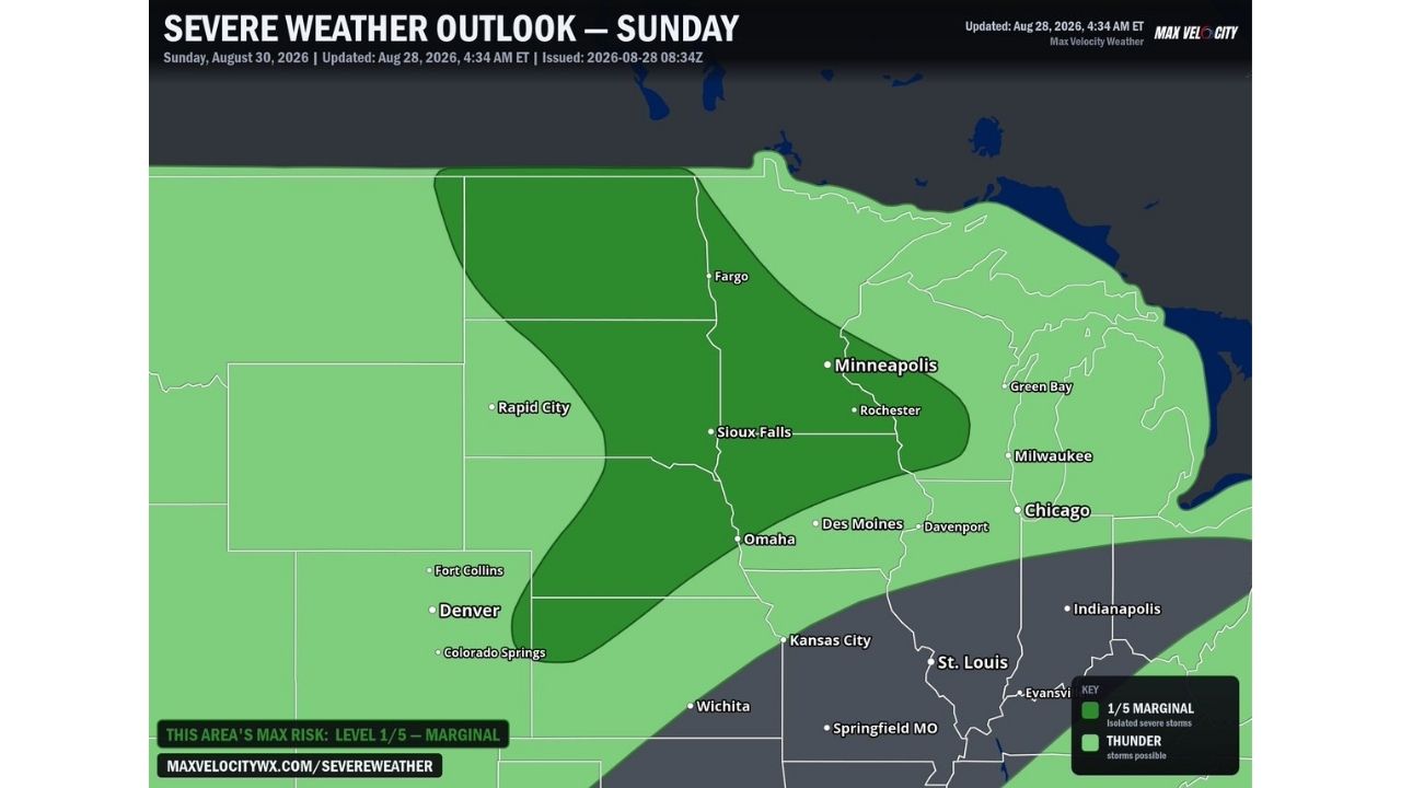
FARGO — A low-end severe threat is possible across the Plains and Upper Mississippi Valley on Sunday, August 30, as a developing storm system could trigger isolated to scattered thunderstorms stretching from the Dakotas down through the Central Plains. Forecasters carry a Marginal Risk (Level 1 of 5) for the corridor, which includes Fargo, Sioux Falls, Minneapolis, Rapid City, and Denver.
A Strong Cap Could Keep the Threat in Check, but Isolated Storms Remain Possible
The Marginal Risk zone stretches in a curved band from North Dakota near Fargo, southwest through South Dakota near Rapid City and Sioux Falls, then bending south into Nebraska and Colorado near Omaha and Denver. Forecasters say the atmosphere would need to destabilize enough to overcome a strong cap currently in place for storms to fully develop, but if that happens, a few cells could produce localized wind and hail. A broader area of general thunderstorm potential is also outlined further east, reaching Minneapolis, Chicago, and Milwaukee.
Why Forecasters Are Calling This a Low-End, Not Widespread, Threat
A Marginal Risk is the lowest tier on the severe weather outlook scale, signaling that any severe storms are expected to stay isolated rather than organized or widespread. The presence of a strong capping inversion is the key limiting factor here, it can suppress storm development entirely unless daytime heating and atmospheric destabilization become strong enough to break through it. Forecasters are explicit that a widespread severe weather event is not anticipated, but they’re also not ruling out a handful of storms strong enough to produce localized wind or hail damage where the cap does erode.
Sunday’s Setup Is Still Two Days From Playing Out
This is a forecast outlook for a period that hasn’t yet begun, issued two days ahead of Sunday’s potential storm development. No watches, warnings, or damage reports currently exist for this event. This article will be updated as Sunday approaches and if storms develop or produce confirmed impacts.
Staying Weather Aware Across a Wide but Low-End Risk Zone
Ahead of Sunday’s potential storms:
- Monitor how the cap behaves through the weekend, that will determine whether storms fully develop
- Have a way to receive warnings ready, even low-end risks can still produce localized damage
- Keep outdoor plans flexible if you’re in the Fargo to Denver corridor Sunday
If isolated storms do develop:
- Move indoors if thunder is heard nearby, even isolated cells can produce sudden wind or hail
- Secure loose outdoor items as a precaution given the localized wind potential
After any storms pass:
- Check for hail or wind damage in areas that saw the strongest isolated cells
- Avoid downed power lines and treat all as live
A Wide Geographic Footprint for a Low-End Setup
What stands out about Sunday’s outlook isn’t the intensity of the threat, it’s the geographic reach, a Marginal Risk zone stretching nearly 700 miles from North Dakota to Colorado, tying together Fargo, Minneapolis, Rapid City, and Denver under the same low-end, cap-dependent severe weather watch.