MEMPHIS — A massive surge of moisture will push dew points into the upper 60s and 70s across much of the eastern United States by Tuesday, September 1, ushering in what forecasters describe as oppressive to miserable humidity from the Gulf Coast to the Great Lakes. Cities including Memphis, Little Rock, New Orleans, Atlanta, and Washington D.C. are all forecast to see dew points climb into territory that makes outdoor conditions feel dramatically worse than the air temperature alone would suggest.
Dew Points Rocket Toward 80 From New Orleans to Atlanta
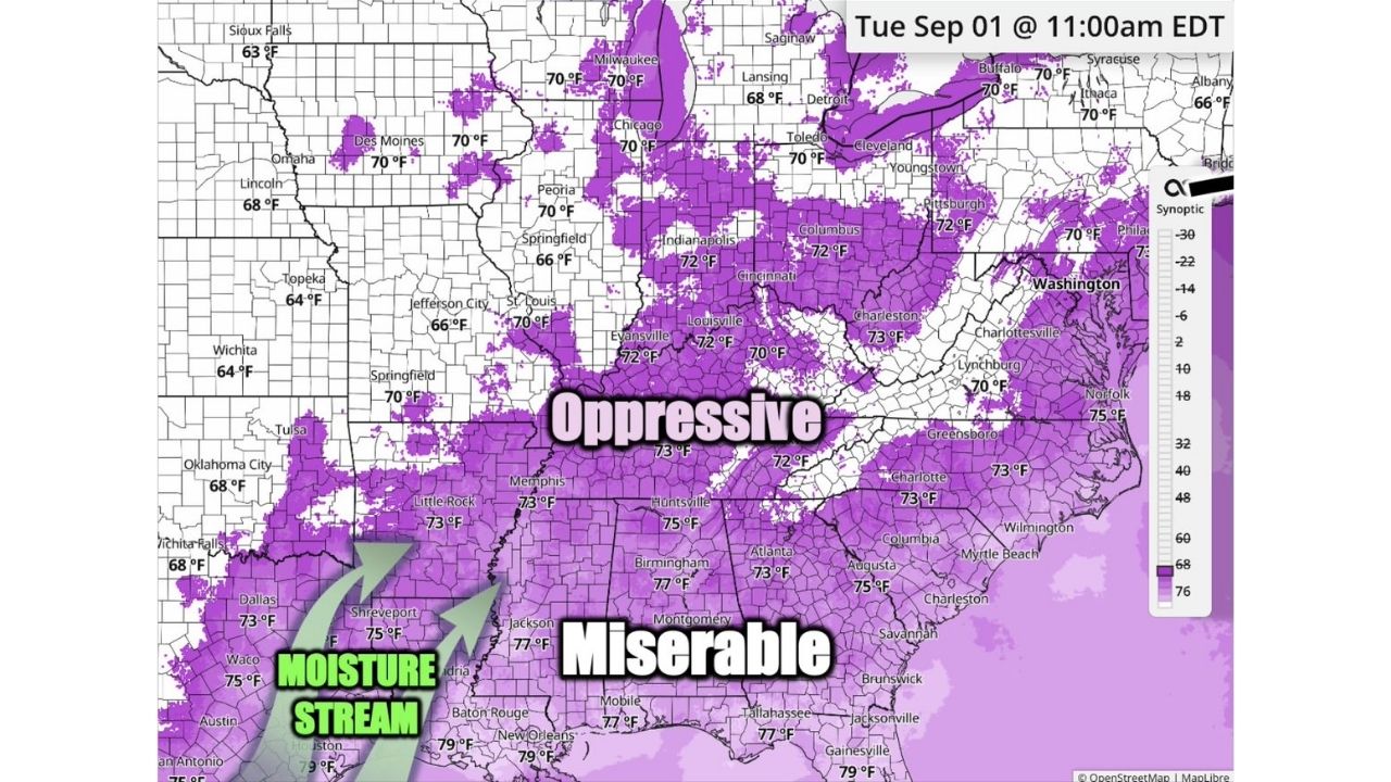
By 11 a.m. EDT Tuesday, dew point readings are forecast to reach 79°F in New Orleans, 77°F in Montgomery and Jacksonville, and 75°F in Memphis, Dallas, Waco, and Huntsville, with a broad band of 70°F-plus dew points stretching as far north as Chicago, Cleveland, and Washington D.C. A moisture stream driving the surge is shown pushing up from the Gulf Coast, feeding oppressive humidity into the Ohio Valley and Mid-Atlantic as the pattern builds through the week.
Why Dew Points in the 70s Feel So Much Worse Than the Thermometer Says
Dew point, not raw air temperature, is what meteorologists rely on to gauge just how muggy the air actually feels, and readings in the 70s are widely considered oppressive, the kind of air where sweat barely evaporates and outdoor activity quickly turns uncomfortable. Once dew points push into the upper 70s, as forecast for New Orleans and Montgomery, conditions cross into what’s often labeled “miserable,” a level of humidity that can make even modest temperatures feel dangerously hot and significantly raises the risk of heat-related illness for anyone spending extended time outdoors.
A Sharp Turn From the Recent Break in Humidity
Forecasters note this marks a clear shift from the more comfortable air many residents have been experiencing, with the moisture surge expected to reverse that trend by early next week. This is a forecast pattern for a period that hasn’t yet arrived, and no heat advisories or humidity-related impacts have been confirmed as of this writing. This article will be updated as the pattern develops heading into September 1.
Getting Ready for a Muggy Start to September
As the moisture surge arrives:
- Stay hydrated throughout the day, especially once dew points climb into the 70s
- Limit strenuous outdoor activity during peak afternoon hours, oppressive humidity raises heat illness risk even at moderate temperatures
- Seek air conditioned spaces periodically, particularly across the Gulf Coast and Southeast where “miserable” conditions are expected
Watching the pattern unfold:
- Expect the muggiest air across the Gulf Coast and Southeast, where dew points are forecast highest
- Monitor how long the pattern lasts, since sustained high humidity compounds heat stress over consecutive days
A Humid Pattern Stretching From the Gulf to the Great Lakes
What stands out about next week’s setup isn’t just the intensity of the humidity in the Deep South, it’s the sheer reach of the moisture surge, pushing oppressive dew points as far north as the Great Lakes and Mid-Atlantic and touching nearly the entire eastern half of the country at once.
For more coverage like this, check back for the latest severe weather updates.