Skip to content

Home

About Us

Advertisement

Contact Us

  • Facebook
  • X
  • Instagram
  • Pinterest
  • WhatsApp
  • RSS Feed
  • TikTok

Dulaney Griffin

Your Trusted Weather Tracker.

Search

104 Year Record on the Brink as Indianapolis, St. Louis Face Warmest Start to September Ever With 90 Degree Days

Melissa Peel Avatar
Melissa Peel
August 28, 2026
104 Year Record on the Brink as Indianapolis, St. Louis Face Warmest Start to September Ever With 90 Degree Days

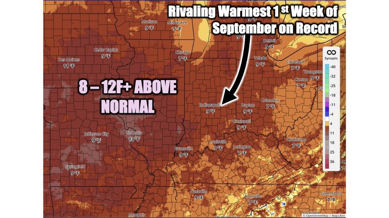
INDIANAPOLIS — The Midwest and Ohio Valley are on track to rival the warmest start to September on record, with temperatures forecast to run 8 to 12°F or more above normal from September 1 through 7. Forecasters say Indianapolis alone could challenge its all-time record for the hottest opening week of September, a mark of 10°F above normal that has stood since 1922, with several days bringing highs in the 90s and overnight lows only dropping into the mid-70s.

St. Louis and Des Moines Lead a Sweeping Warm Anomaly Across the Heartland

The departure-from-normal map shows the anomaly stretching across a massive footprint, from Des Moines and Cedar Rapids in Iowa through Chicago, Indianapolis, and Columbus, and south into Louisville, Nashville, and Memphis. St. Louis posts the single highest anomaly on the map at 13°F above normal, while most of the region, including Cincinnati, Dayton, Cleveland, and Evansville, sits consistently in the 7 to 9°F above normal range for the week-long stretch.

Why Nearly a Full Week of 90 Degree Heat in September Is a Big Deal

A single hot day this time of year isn’t unusual, but forecasters are flagging this setup because of its duration and consistency: several days with highs in the 90s paired with lows only falling to the mid-70s means little overnight relief across a huge swath of the country, right as the calendar turns toward fall. Indianapolis’s potential to challenge a 104-year-old record underscores just how far outside the norm this stretch is shaping up to be, not a fluke warm day, but a sustained, record-threatening heat anomaly spanning the entire first week of September.

This Record Bid Hasn’t Played Out Yet

This outlook covers a forecast period that has not yet begun, and no daily records have been broken as of this writing. This article will be updated as the September 1 to 7 window unfolds and if daily or all-time records are confirmed broken.

Getting Ready for a Scorching Start to September

As the heat wave approaches:

  • Prepare for little overnight relief, with lows only in the mid-70s, indoor cooling remains important even after sunset
  • Limit outdoor activity during peak afternoon heat, especially with highs reaching the 90s on multiple days
  • Check on vulnerable neighbors and relatives, sustained heat raises risk with each consecutive hot day

Throughout the week-long stretch:

  • Stay hydrated consistently, not just on the hottest single day, since the anomaly persists for days
  • Watch for local heat advisories, which often follow outlooks like this one as the pattern firms up

A Historic Heat Anomaly to Close Out Summer

With Indianapolis eyeing a record that has stood since 1922 and anomalies topping 13°F above normal in spots like St. Louis, this isn’t shaping up as an ordinary warm week, it’s a heat pattern with the ingredients to rewrite the record books just as much of the country expects fall’s first real cooldown.

For more coverage like this, check back for the latest severe weather updates.

Featured Articles

  • Damaging Wind Gusts and Hail Loom Over Central Wisconsin as Forecasters Lock In on Sunday Evening Storm Threat

    Damaging Wind Gusts and Hail Loom Over Central Wisconsin as Forecasters Lock In on Sunday Evening Storm Threat

    August 28, 2026
  • Isolated Wind and Hail Threat Stretches 700 Miles From Fargo to Denver as Storms Eye Sunday Breakthrough

    Isolated Wind and Hail Threat Stretches 700 Miles From Fargo to Denver as Storms Eye Sunday Breakthrough

    August 28, 2026
  • Explosive Rain Bomb Set to Drench Minnesota and Western Wisconsin as Powerful Jet Dynamics Collide Saturday

    Explosive Rain Bomb Set to Drench Minnesota and Western Wisconsin as Powerful Jet Dynamics Collide Saturday

    August 28, 2026
  • Oppressive 79 Degree Dew Points Set to Blanket Eastern US as Miserable Moisture Surge Targets Millions Next Week

    Oppressive 79 Degree Dew Points Set to Blanket Eastern US as Miserable Moisture Surge Targets Millions Next Week

    August 28, 2026
  • 75 MPH Hurricane Force Winds Set to Slam Salt Lake City and Rapid City Saturday in Explosive Two State Threat

    75 MPH Hurricane Force Winds Set to Slam Salt Lake City and Rapid City Saturday in Explosive Two State Threat

    August 28, 2026

Search

Follow Us on

  • Facebook
  • X
  • Instagram
  • VK
  • Pinterest
  • Last.fm
  • TikTok
  • Telegram
  • WhatsApp
  • RSS Feed

Categories

  • Forecast (58)

About Us

dulaneygriffin

Dulaney Griffin tracks storms, tornado risk, heat and snow across the United States, using National Weather Service and NOAA data. For active warnings in your area, always follow the National Weather Service and your local emergency officials.

Latest Articles

  • Damaging Wind Gusts and Hail Loom Over Central Wisconsin as Forecasters Lock In on Sunday Evening Storm Threat

    Damaging Wind Gusts and Hail Loom Over Central Wisconsin as Forecasters Lock In on Sunday Evening Storm Threat

    August 28, 2026
  • Isolated Wind and Hail Threat Stretches 700 Miles From Fargo to Denver as Storms Eye Sunday Breakthrough

    Isolated Wind and Hail Threat Stretches 700 Miles From Fargo to Denver as Storms Eye Sunday Breakthrough

    August 28, 2026
  • Explosive Rain Bomb Set to Drench Minnesota and Western Wisconsin as Powerful Jet Dynamics Collide Saturday

    Explosive Rain Bomb Set to Drench Minnesota and Western Wisconsin as Powerful Jet Dynamics Collide Saturday

    August 28, 2026

Categories

  • Forecast (58)
  • Instagram
  • Facebook
  • LinkedIn
  • X
  • VK
  • TikTok

Proudly Powered by WordPress | JetNews Magazine by CozyThemes.

Scroll to Top