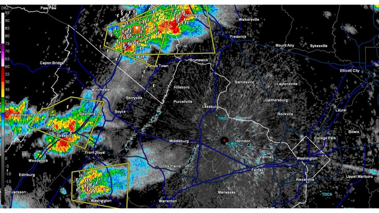
CHARLES TOWN — Slow-moving storms currently sitting west of the region are set to cross the Blue Ridge over the next hour, tracking east at roughly 20 mph toward Winchester, Leesburg, and the DC metro area, according to a 5:45 p.m. update. Forecasters are warning of frequent lightning, damaging wind reports, and a flash flooding threat north of Charles Town, where 2 to 4 inches or more of rain are expected.
Storm Clusters Line Up From Strasburg to Charles Town Ahead of a Slow Eastward Push
Radar shows multiple severe-warned storm cells stretching along a north-south line, with the most intense activity positioned near Charles Town and Brunswick to the north and additional cells tracking through Strasburg, Stephens City, and Front Royal to the south. A third cell is also visible near Washington, Virginia, further south along the same line. All of the activity remains west of the Blue Ridge as of the update, but is forecast to cross the mountains and continue east at around 20 mph over the next hour, putting Leesburg, Purcellville, and the outer DC suburbs in the path as the evening progresses.
Why the Charles Town Rainfall Numbers Stand Out
While lightning and damaging wind reports are affecting the broader line of storms, the flash flooding threat north of Charles Town is the sharpest concern in this update. Rainfall totals of 2 to 4 inches or more falling from slow-moving storms can quickly overwhelm creeks, low-lying roads, and drainage systems, especially when storms train repeatedly over the same area rather than moving through quickly. The storms’ relatively slow 20 mph forward speed is what’s driving that heightened rainfall potential in the Charles Town area specifically.
No Confirmed Damage Yet as Storms Push Toward the Blue Ridge
As of this writing, damaging wind reports have been noted with this activity, but no flooding, structural damage, or injury reports specific to this update have been confirmed. This article will be updated as the storms cross the Blue Ridge and move into the DC metro area, and if additional damage or flooding reports come in.
What to Do as These Storms Track Toward the DC Metro
Over the next hour:
- Move indoors now if you’re anywhere along the storms’ eastward path, including Leesburg, Purcellville, and Winchester
- Avoid low-lying roads near Charles Town, given the 2 to 4 inch-plus rainfall threat in that area
- Stay away from windows given the frequent lightning and damaging wind reports
As storms cross the Blue Ridge:
- Never drive through flooded roadways, turn around, don’t drown
- Watch for sudden wind gusts as cells move over higher terrain and into the Piedmont
After storms pass:
- Avoid downed power lines and treat all as live
- Check for flash flooding on roads near Charles Town and surrounding areas well after the rain ends
A Line of Storms With the DC Metro Next in Line
With multiple severe-warned cells still west of the Blue Ridge but closing in at a steady 20 mph, the storm line is on track to reach the Leesburg and outer DC metro area within the hour, carrying lightning, damaging wind potential, and a locally significant flash flooding threat tied to the heaviest rain near Charles Town.
For more coverage like this, check back for the latest severe weather updates.