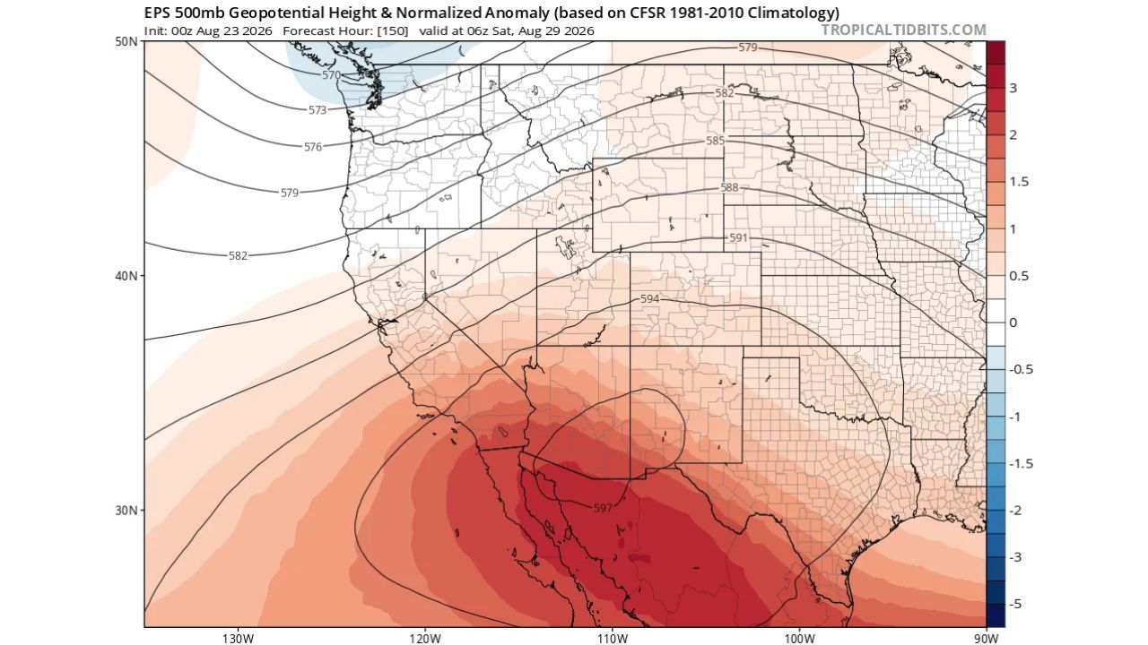
LOS ANGELES — A major heatwave is building across Southern California this week, driven by a strong ridge of high pressure parked over the Southwest, according to the latest pattern outlook. Forecasters are also flagging a modest but growing possibility that tropical storm remnants could affect California as the pattern evolves into September.
What the Pattern Shows
The setup centers on a strengthening upper-level ridge over the Southwest, with the strongest heat anomalies concentrated across Southern California, Arizona, and the surrounding desert Southwest. That ridge is expected to drive the late August heatwave this week, while forecasters separately note the anomaly pattern could open the door to tropical moisture or storm remnants reaching California once the calendar turns to September.
Why This Pattern Matters
Ridging of this strength typically locks in place for days at a time, which is why forecasters are calling this a major heatwave rather than a brief warm spell. Some forecasters also note that parts of Southern California could potentially see even more extreme heat than currently reflected in official forecasts, meaning there’s room for the pattern to intensify further as the week progresses. The tropical remnant possibility being raised alongside the heatwave is still described as only a modest, growing chance, not a confirmed track or system, but it’s being watched as part of the same evolving pattern into September.
Where Things Stand
This is a developing pattern rather than a confirmed event with specific temperatures or timing attached. No official heat warnings, advisories, or tropical system data have been confirmed as part of this outlook. This article will be updated as more specific forecast details, including actual temperature forecasts and any tropical development, become available.
Heat Pattern Preparedness Guide
As the heatwave builds:
- Watch for official heat products: Excessive Heat Warnings or Heat Advisories are likely as the pattern firms up this week
- Limit outdoor activity during peak afternoon hours as the ridge strengthens
- Stay hydrated and check on vulnerable neighbors as the heat builds in
Looking toward September:
- Monitor tropical outlooks if you’re in California, given the growing possibility of remnant moisture reaching the state
- Don’t assume the heat pattern is fixed: forecasters note actual conditions could run hotter than current forecasts indicate
A Pattern With Two Storylines to Watch
This week’s setup carries two separate threads worth tracking, an intensifying Southern California heatwave in the near term, and a longer-range, still-uncertain chance that tropical remnants could reach California in September. Together, they underscore an active and evolving pattern across the Southwest as summer transitions toward fall.
For more coverage like this, visit Eye of the Hurricane News for the latest severe weather updates.