Skip to content

Home

About Us

Advertisement

Contact Us

  • Facebook
  • X
  • Instagram
  • Pinterest
  • WhatsApp
  • RSS Feed
  • TikTok

Dulaney Griffin

Your Trusted Weather Tracker.

Search

55 to 70 MPH Wind Gusts Possible as Severe Storm Watch Eyed for Fayetteville, Wilmington, Myrtle Beach This Afternoon

Melissa Peel Avatar
Melissa Peel
August 24, 2026
55 to 70 MPH Wind Gusts Possible as Severe Storm Watch Eyed for Fayetteville, Wilmington, Myrtle Beach This Afternoon

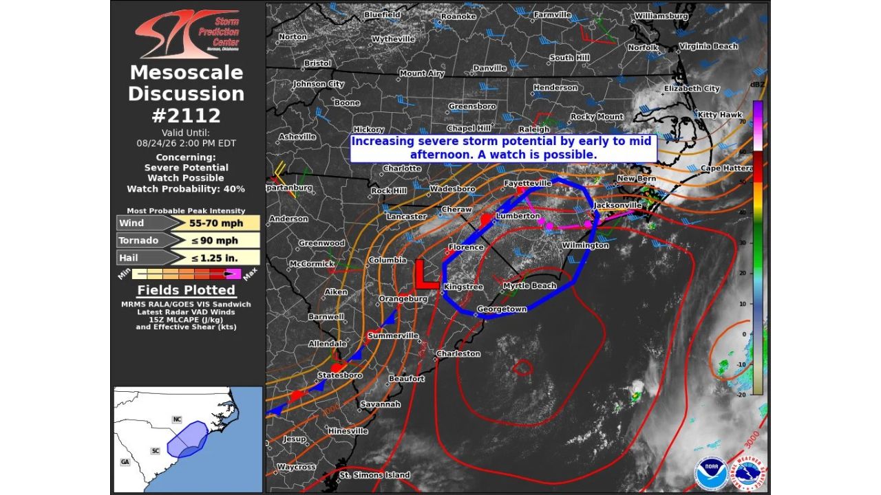
FAYETTEVILLE — The Storm Prediction Center issued Mesoscale Discussion #2112 at 10:31 a.m. CDT Monday, flagging increasing severe storm potential across parts of the Carolinas, including Fayetteville, Lumberton, Wilmington, and Myrtle Beach, by early to mid afternoon. Forecasters say a severe thunderstorm watch is possible, with a 40% probability of one being issued before the discussion expires at 2 p.m. EDT.

What the Discussion Covers

  • Valid until: 2:00 p.m. EDT, Monday, August 24
  • Watch probability: 40%
  • Most probable peak wind: 55 to 70 mph
  • Most probable peak tornado wind: 90 mph or less
  • Most probable peak hail: 1.25 inches or less
  • Area affected: stretches from inland near Fayetteville southeast through Lumberton, Florence, and Kingstree to the coast near Wilmington, Myrtle Beach, and Georgetown

Why a Mesoscale Discussion Matters

A Mesoscale Discussion is issued when forecasters see conditions coming together that could require a formal watch, but haven’t yet crossed that threshold. It’s a heads-up product, meant to bridge the gap between routine outlooks and an actual severe thunderstorm or tornado watch. With a 40% watch probability attached and peak wind gusts estimated between 55 and 70 mph, this discussion signals that forecasters are watching the atmosphere closely over the next few hours as storms develop across the region.

Where Things Stand

This discussion is valid through 2 p.m. EDT and reflects a developing situation rather than a confirmed severe weather event. No watch has been issued as of this writing, and no damage or storm reports have been confirmed. This article will be updated if the Storm Prediction Center issues a formal watch or if storm reports come in from the affected area.

Severe Weather Safety Guide

Before storms develop:

  • Stay weather aware through early afternoon: conditions are expected to become more favorable for severe storms as the day progresses
  • Have a way to receive alerts: a weather radio or phone notifications will be critical if a watch or warning is issued
  • Secure loose outdoor items ahead of potential wind gusts up to 70 mph

If a watch or warning is issued:

  • Move to an interior room away from windows if a warning is issued for your location
  • Avoid travel through the affected corridor if storms are actively developing nearby

After storms pass:

  • Avoid downed power lines and treat all as live
  • Check for damage before heading outside, especially in areas that saw the strongest wind gusts

Part of an Active Afternoon Across the Carolinas

Monday’s discussion adds to what has been an unsettled pattern across the Carolinas, with radar and satellite data showing numerous developing storm cells stretching from inland North Carolina down through the South Carolina coast. Whether or not a formal watch is issued, the setup underscores an active severe weather threat building into the afternoon and evening hours.

For more coverage like this, visit Eye of the Hurricane News for the latest severe weather updates.
Featured Articles

  • Low End Tornado Threat Emerges for Tuesday Across Northern Minnesota as 2 Percent Probability Zone Targets Duluth, St. Cloud

    Low End Tornado Threat Emerges for Tuesday Across Northern Minnesota as 2 Percent Probability Zone Targets Duluth, St. Cloud

    August 24, 2026
  • Major Heatwave Builds Over Southern California This Week as Forecasters Also Watch Growing Chance of Tropical Storm Remnants in September

    Major Heatwave Builds Over Southern California This Week as Forecasters Also Watch Growing Chance of Tropical Storm Remnants in September

    August 24, 2026
  • 55 to 70 MPH Wind Gusts Possible as Severe Storm Watch Eyed for Fayetteville, Wilmington, Myrtle Beach This Afternoon

    55 to 70 MPH Wind Gusts Possible as Severe Storm Watch Eyed for Fayetteville, Wilmington, Myrtle Beach This Afternoon

    August 24, 2026
  • Near Average Temperatures, Rain Chances Expected for Pennsylvania and Northeast as Highs Stay in 60s and 70s Through Early September

    Near Average Temperatures, Rain Chances Expected for Pennsylvania and Northeast as Highs Stay in 60s and 70s Through Early September

    August 24, 2026
  • Triple Digit Heat Nears 110 Degrees Monday as Dallas, Wichita Falls, Lawton, Oklahoma City Chase Record Highs Across Southern Plains

    Triple Digit Heat Nears 110 Degrees Monday as Dallas, Wichita Falls, Lawton, Oklahoma City Chase Record Highs Across Southern Plains

    August 24, 2026

Search

Follow Us on

  • Facebook
  • X
  • Instagram
  • VK
  • Pinterest
  • Last.fm
  • TikTok
  • Telegram
  • WhatsApp
  • RSS Feed

Categories

  • Forecast (34)

About Us

dulaneygriffin

Dulaney Griffin tracks storms, tornado risk, heat and snow across the United States, using National Weather Service and NOAA data. For active warnings in your area, always follow the National Weather Service and your local emergency officials.

Latest Articles

  • Low End Tornado Threat Emerges for Tuesday Across Northern Minnesota as 2 Percent Probability Zone Targets Duluth, St. Cloud

    Low End Tornado Threat Emerges for Tuesday Across Northern Minnesota as 2 Percent Probability Zone Targets Duluth, St. Cloud

    August 24, 2026
  • Major Heatwave Builds Over Southern California This Week as Forecasters Also Watch Growing Chance of Tropical Storm Remnants in September

    Major Heatwave Builds Over Southern California This Week as Forecasters Also Watch Growing Chance of Tropical Storm Remnants in September

    August 24, 2026
  • 55 to 70 MPH Wind Gusts Possible as Severe Storm Watch Eyed for Fayetteville, Wilmington, Myrtle Beach This Afternoon

    55 to 70 MPH Wind Gusts Possible as Severe Storm Watch Eyed for Fayetteville, Wilmington, Myrtle Beach This Afternoon

    August 24, 2026

Categories

  • Forecast (34)
  • Instagram
  • Facebook
  • LinkedIn
  • X
  • VK
  • TikTok

Proudly Powered by WordPress | JetNews Magazine by CozyThemes.

Scroll to Top