Skip to content

Home

About Us

Advertisement

Contact Us

  • Facebook
  • X
  • Instagram
  • Pinterest
  • WhatsApp
  • RSS Feed
  • TikTok

Dulaney Griffin

Your Trusted Weather Tracker.

Search

Torrential Downpours and Strong Wind Gusts Take Aim at New York City Metro Within Two Hours as Storms Push North From Trenton

Melissa Peel Avatar
Melissa Peel
August 27, 2026
Torrential Downpours and Strong Wind Gusts Take Aim at New York City Metro Within Two Hours as Storms Push North From Trenton

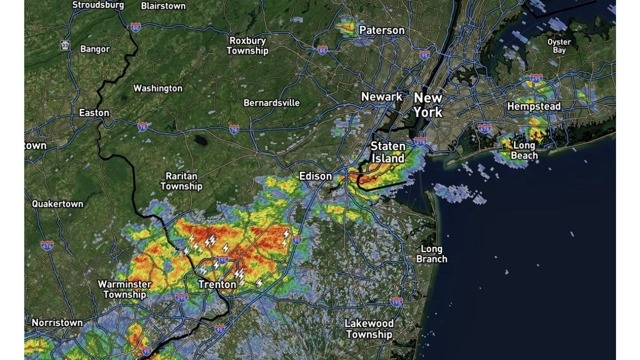
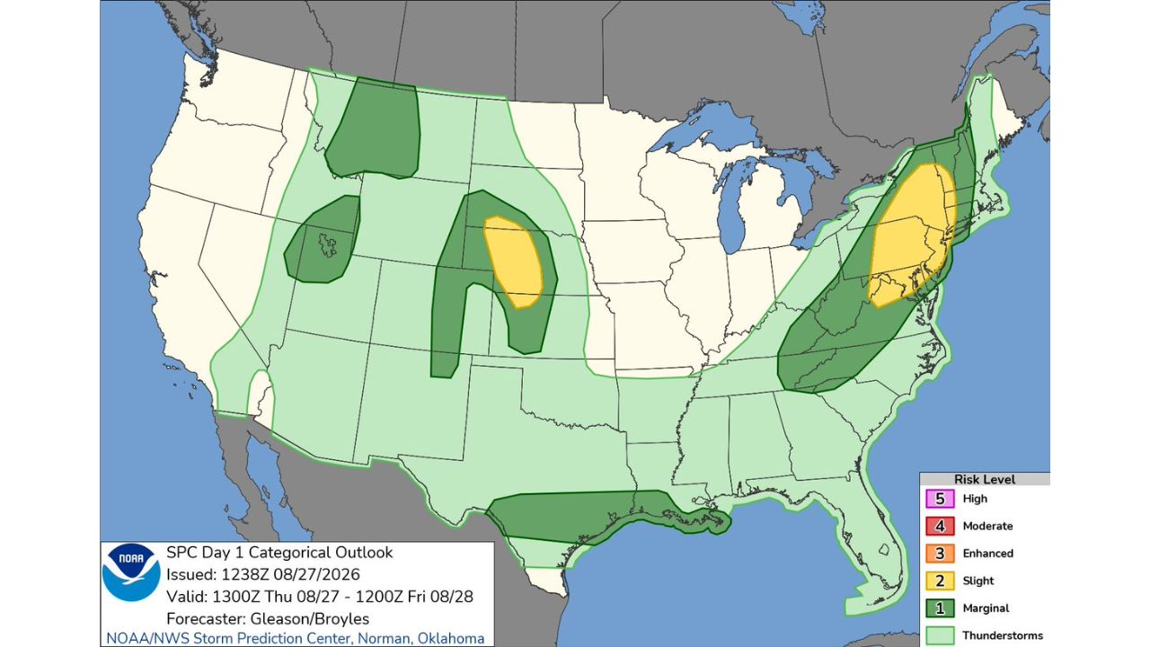
NEW YORK — Showers and thunderstorms strengthening southwest of the New York City metro area are expected to spread north and east into the region over the next one to two hours, according to a 12:15 p.m. update. Forecasters warn the approaching storms could bring torrential downpours, localized flash flooding, and strong wind gusts as they track toward Newark, Staten Island, and New York City.

Storms Strengthening Near Trenton Track Toward the Five Boroughs

Radar shows an organized cluster of storms currently positioned near Trenton and Edison, already producing heavy rain, with additional development visible near Paterson to the north. As of 12:15 p.m., that activity is forecast to spread north and east over the next one to two hours, putting the core of the New York City metro, including Newark, Staten Island, and Long Island, in the path of the heaviest rain and strongest winds as the afternoon progresses.

Fast-Moving Downpours Raise Quick Flooding Risk in a Dense Urban Corridor

Torrential rain falling over a short window is especially disruptive in a heavily paved, densely populated area like the NYC metro, where storm drains can be overwhelmed quickly, leading to localized flash flooding on streets, underpasses, and low-lying areas. Combined with strong wind gusts, the setup also raises the risk of downed limbs and temporary power disruptions as the storms move through.

No Formal Warning Yet, but Storms Are Close and Strengthening

As of this writing, this is a short-fuse forecast update rather than a confirmed flash flood or severe thunderstorm warning. No flooding or wind damage has been confirmed. This article will be updated if the National Weather Service issues warnings or if impacts are reported as the storms move through the metro area.

What to Do in the Next Two Hours

Before the storms arrive:

  • Move outdoor plans indoors now, storms are expected to arrive within one to two hours
  • Avoid parking in flood-prone underpasses or low-lying streets
  • Check your commute, torrential rain can quickly slow traffic and flood roadways across the metro area

As storms move through:

  • Never drive through flooded streets, even shallow-looking water can stall a vehicle quickly
  • Stay indoors during the heaviest rain and wind gusts
  • Watch for ponding on highways and underpasses, common trouble spots during fast, heavy downpours

After the storms pass:

  • Avoid standing water on roads, it can hide debris or flooded potholes
  • Check for downed limbs or wires before heading back outside

A Fast-Developing Threat for Millions in the Metro Corridor

With storms already strengthening just southwest of the city and expected to arrive within a couple of hours, residents across the New York City metro have a narrow window to prepare before torrential rain, potential flash flooding, and gusty winds move through one of the country’s most densely populated corridors.

For more coverage like this, check back for the latest severe weather updates.
Featured Articles

  • Twin Slight Risk Zones Explode Across Central Plains and NYC to Boston Corridor Today as Severe Storms Threaten Millions

    Twin Slight Risk Zones Explode Across Central Plains and NYC to Boston Corridor Today as Severe Storms Threaten Millions

    August 27, 2026
  • 60 MPH Winds and Isolated Tornado Threat Could Trigger Watch Across New York City Metro to Atlantic City by Early Afternoon

    60 MPH Winds and Isolated Tornado Threat Could Trigger Watch Across New York City Metro to Atlantic City by Early Afternoon

    August 27, 2026
  • Muggy 80 Degree Mornings Blur the Line Between Southern California and Florida as Heat Illness Risk Spikes

    Muggy 80 Degree Mornings Blur the Line Between Southern California and Florida as Heat Illness Risk Spikes

    August 27, 2026
  • Critical Fire Weather Conditions Target Far Northeastern California, Northwestern Nevada Today as Elevated Risk Spreads Into Oregon

    Critical Fire Weather Conditions Target Far Northeastern California, Northwestern Nevada Today as Elevated Risk Spreads Into Oregon

    August 27, 2026
  • Torrential Downpours and Strong Wind Gusts Take Aim at New York City Metro Within Two Hours as Storms Push North From Trenton

    Torrential Downpours and Strong Wind Gusts Take Aim at New York City Metro Within Two Hours as Storms Push North From Trenton

    August 27, 2026

Search

Follow Us on

  • Facebook
  • X
  • Instagram
  • VK
  • Pinterest
  • Last.fm
  • TikTok
  • Telegram
  • WhatsApp
  • RSS Feed

Categories

  • Forecast (50)

About Us

dulaneygriffin

Dulaney Griffin tracks storms, tornado risk, heat and snow across the United States, using National Weather Service and NOAA data. For active warnings in your area, always follow the National Weather Service and your local emergency officials.

Latest Articles

  • Twin Slight Risk Zones Explode Across Central Plains and NYC to Boston Corridor Today as Severe Storms Threaten Millions

    Twin Slight Risk Zones Explode Across Central Plains and NYC to Boston Corridor Today as Severe Storms Threaten Millions

    August 27, 2026
  • 60 MPH Winds and Isolated Tornado Threat Could Trigger Watch Across New York City Metro to Atlantic City by Early Afternoon

    60 MPH Winds and Isolated Tornado Threat Could Trigger Watch Across New York City Metro to Atlantic City by Early Afternoon

    August 27, 2026
  • Muggy 80 Degree Mornings Blur the Line Between Southern California and Florida as Heat Illness Risk Spikes

    Muggy 80 Degree Mornings Blur the Line Between Southern California and Florida as Heat Illness Risk Spikes

    August 27, 2026

Categories

  • Forecast (50)
  • Instagram
  • Facebook
  • LinkedIn
  • X
  • VK
  • TikTok

Proudly Powered by WordPress | JetNews Magazine by CozyThemes.

Scroll to Top