Skip to content

Home

About Us

Advertisement

Contact Us

  • Facebook
  • X
  • Instagram
  • Pinterest
  • WhatsApp
  • RSS Feed
  • TikTok

Dulaney Griffin

Your Trusted Weather Tracker.

Search

Northern Great Basin, Gulf Coast and Maine Join Marginal Risk Zone as Monday’s Severe Outlook Expands

Melissa Peel Avatar
Melissa Peel
August 23, 2026
Northern Great Basin, Gulf Coast and Maine Join Marginal Risk Zone as Monday’s Severe Outlook Expands

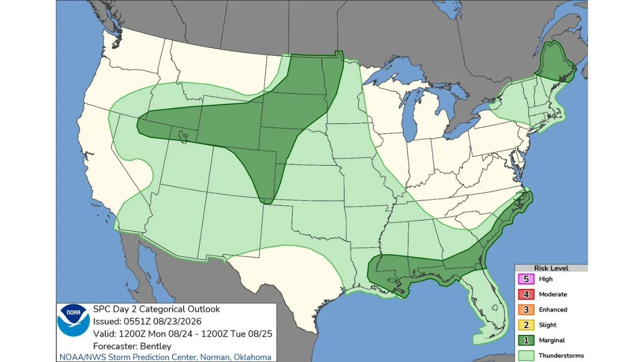
RAPID CITY — Monday’s Marginal Risk footprint grew significantly in the Storm Prediction Center’s latest Day 2 outlook, now spanning three separate regions: the northern Great Basin into the central High Plains and northern Plains, a Gulf Coast corridor stretching from Louisiana into the Florida Panhandle, and a pocket over northern Maine. The outlook, issued at 0551Z, is valid 1200Z Monday, Aug. 24 through 1200Z Tuesday, Aug. 25.

  • Risk level: Marginal (1 of 5)
  • Zone 1: northern Great Basin into central High Plains and northern Plains, roughly Idaho/Montana through the Dakotas
  • Zone 2: Gulf Coast, Louisiana through the Florida Panhandle
  • Zone 3: northern Maine
  • Valid: 1200Z Mon., Aug. 24 through 1200Z Tue., Aug. 25
  • Forecaster: Bentley, SPC Norman, Oklahoma

How This Outlook Changed From the Earlier Day 3 Look

Just a day earlier, the Storm Prediction Center’s Day 3 outlook for this same Monday flagged a single Marginal Risk zone confined to the central and northern Plains. This updated Day 2 version keeps that Plains zone largely intact but adds two entirely new areas, a Gulf Coast band and a separate pocket over northern Maine, that weren’t part of the earlier outlook at all. That kind of expansion between Day 3 and Day 2 outlooks is typical as forecasters gain more confidence and finer detail closer to the event, but the addition of two geographically distant new zones shows just how much a forecast picture can shift in just 24 hours.

What to Watch For as Monday Approaches

As of this writing, this remains a Day 2 outlook and does not represent a confirmed watch or warning in any of the three zones. No severe thunderstorm watches have been issued, and none would be expected this far in advance. This article will be updated as the outlook is refined further in the Day 1 update closer to Monday.

For more coverage like this, check back for the latest severe weather updates.
Featured Articles

  • Police Say Two Young Passengers Are in Critical Condition After a Crash Near Sherman Boulevard and Silver Spring Drive on Milwaukee’s North Side Wednesday Night

    Police Say Two Young Passengers Are in Critical Condition After a Crash Near Sherman Boulevard and Silver Spring Drive on Milwaukee’s North Side Wednesday Night

    September 5, 2026
  • Kenosha Man Charged After Glendale Police Chase Ends in Fox Point Crash That Hurt a 1-Year-Old Child and Reached 97 Mph

    Kenosha Man Charged After Glendale Police Chase Ends in Fox Point Crash That Hurt a 1-Year-Old Child and Reached 97 Mph

    September 5, 2026
  • Pickup Truck Crashes Into Pennsylvania State Police Barracks in Cherry Ridge Township, Injuring Officer and Leaving Honesdale Station Communications Disrupted

    Pickup Truck Crashes Into Pennsylvania State Police Barracks in Cherry Ridge Township, Injuring Officer and Leaving Honesdale Station Communications Disrupted

    September 5, 2026
  • Honesdale Man Accused of Crashing Beer Filled Pickup Into Pennsylvania State Police Station, Injuring Communications Officer and Telling Trooper He Was Drunk

    Honesdale Man Accused of Crashing Beer Filled Pickup Into Pennsylvania State Police Station, Injuring Communications Officer and Telling Trooper He Was Drunk

    September 5, 2026
  • UW-Madison Police Investigate Three Reported Sexual Assaults on Campus in Two Weeks, Including a Recent Southeast Residence Hall Case and Charges in Another Attack

    UW-Madison Police Investigate Three Reported Sexual Assaults on Campus in Two Weeks, Including a Recent Southeast Residence Hall Case and Charges in Another Attack

    September 5, 2026

Search

Follow Us on

  • Facebook
  • X
  • Instagram
  • VK
  • Pinterest
  • Last.fm
  • TikTok
  • Telegram
  • WhatsApp
  • RSS Feed

Categories

  • Crash Board (15)
  • Forecast (68)
  • Last Seen (3)
  • Sheriff's Log (12)

About Us

dulaneygriffin

Dulaney Griffin tracks storms, tornado risk, heat and snow across the United States, using National Weather Service and NOAA data. For active warnings in your area, always follow the National Weather Service and your local emergency officials.

Latest Articles

  • Police Say Two Young Passengers Are in Critical Condition After a Crash Near Sherman Boulevard and Silver Spring Drive on Milwaukee’s North Side Wednesday Night

    Police Say Two Young Passengers Are in Critical Condition After a Crash Near Sherman Boulevard and Silver Spring Drive on Milwaukee’s North Side Wednesday Night

    September 5, 2026
  • Kenosha Man Charged After Glendale Police Chase Ends in Fox Point Crash That Hurt a 1-Year-Old Child and Reached 97 Mph

    Kenosha Man Charged After Glendale Police Chase Ends in Fox Point Crash That Hurt a 1-Year-Old Child and Reached 97 Mph

    September 5, 2026
  • Pickup Truck Crashes Into Pennsylvania State Police Barracks in Cherry Ridge Township, Injuring Officer and Leaving Honesdale Station Communications Disrupted

    Pickup Truck Crashes Into Pennsylvania State Police Barracks in Cherry Ridge Township, Injuring Officer and Leaving Honesdale Station Communications Disrupted

    September 5, 2026

Categories

  • Crash Board (15)
  • Forecast (68)
  • Last Seen (3)
  • Sheriff's Log (12)
  • Instagram
  • Facebook
  • LinkedIn
  • X
  • VK
  • TikTok

Proudly Powered by WordPress | JetNews Magazine by CozyThemes.

Scroll to Top