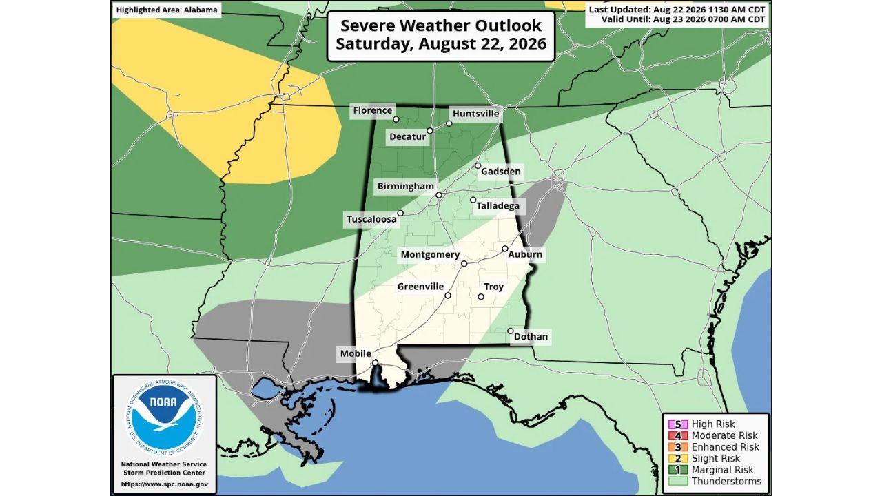
HUNTSVILLE — The Storm Prediction Center introduced a Marginal Risk (Level 1 of 5) of severe thunderstorms for late Saturday afternoon and overnight across north and west Alabama, generally for areas north of I-59, including Florence, Huntsville, Decatur and Birmingham. While most of the state stayed rain-free Saturday afternoon, high-resolution models suggested a mass of thunderstorms could form over Arkansas later in the day, then move into north Mississippi and northwest Alabama overnight.
- Risk level: Marginal (1 of 5)
- Highlighted area: north and west Alabama, generally north of I-59
- Valid until: 7 a.m. CDT, Sunday, Aug. 23, 2026
- Trigger: possible thunderstorm development over Arkansas, moving into north Mississippi and northwest Alabama
- Hazard if storms form: strong wind gusts
- Highest-risk window: roughly 8 p.m. to midnight Saturday night
- Cities in the outlook: Florence, Huntsville, Decatur, Birmingham, Tuscaloosa, Gadsden
Why This Was a Conditional “If They Do Form” Threat
What set this outlook apart was its explicit uncertainty about whether storms would even develop at all. Rather than describing an active or highly probable system, the source specifically framed this as storms that “if they do form” could produce strong wind gusts, based on high-resolution model guidance rather than a confirmed, organized system already tracking toward Alabama. That conditional framing, combined with the low Marginal designation, meant residents in the Florence-to-Birmingham corridor were being given an early heads-up on a possible late-evening threat rather than a high-confidence forecast.
What Happened as the Overnight Window Passed
As of this writing, this outlook was valid through 7 a.m. Sunday, with the highest risk window identified as roughly 8 p.m. to midnight Saturday. No confirmed severe weather reports, wind damage, or storm activity tied to this outlook have been published in the data available. This article will be updated if confirmed storm reports or damage from Saturday night become available.
For more coverage like this, check back for the latest severe weather updates.