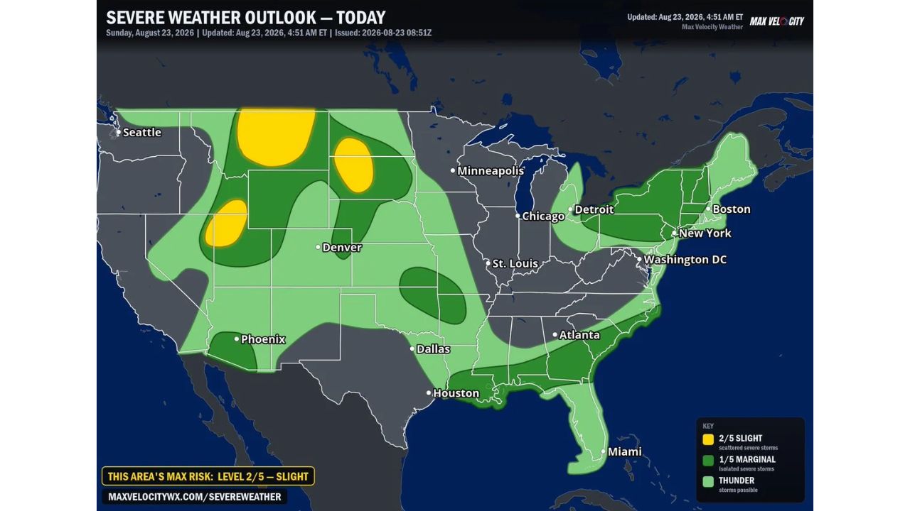
BILLINGS — Three separate Slight Risk zones cover parts of the Northern Plains and Intermountain West Sunday, with the most notable threat developing over central Montana early this afternoon, where supercells capable of large hail are expected to spread into the Dakotas and Nebraska Panhandle through the evening before congealing into storm clusters capable of widespread, significant damaging wind gusts.
Farther west, gusty thunderstorms pose a localized wind damage risk across northern Utah and eastern Nevada by late afternoon. Separately, scattered strong storms will bring a localized downburst threat to parts of the Northeast and Southeast, followed by an overnight cluster capable of strong winds pushing through southeast Kansas, northeast Oklahoma and the Ozarks.
Four Storm Modes, One Outlook
- Central Montana into the Dakotas and Nebraska Panhandle: supercells with large hail this afternoon, congealing into damaging-wind storm clusters by evening
- Northern Utah and eastern Nevada: gusty thunderstorms, localized wind damage risk by late afternoon
- Northeast and Southeast: scattered strong storms, localized damaging downburst threat
- Southeast Kansas, northeast Oklahoma, the Ozarks: overnight storm cluster capable of strong winds
- Overall max risk: Level 2 of 5, Slight
- Issued: 4:51 a.m. ET, Aug. 23, 2026
Why the Montana Storm’s Evolution Matters Most
Of the four separate threats flagged today, the Montana-to-Dakotas system carries the most complex evolution and arguably the highest overall impact. Storms that begin as discrete supercells, capable of producing large hail in isolated but intense cells, don’t always go on to organize into a broader cluster. When they do congeal, as forecasters expect here, the danger shifts from a localized hail threat within individual storms to a widespread wind event capable of affecting a much larger area at once. That transition from supercells to a merged cluster is why this particular zone carries language about “widespread, significant” wind gusts, a step up from the more contained damage typically expected from isolated storms.
What to Watch For as All Four Zones Develop
As of this writing, this is a Day 1 outlook with today’s severe weather still ahead across all four highlighted regions. No severe thunderstorm watches tied to any of the zones, Montana/Dakotas, Utah/Nevada, the Northeast/Southeast, or the Ozarks corridor, have been issued yet. This article will be updated as watches, warnings, or storm reports develop throughout the day and into the overnight hours.
For more coverage like this, check back for the latest severe weather updates.