Skip to content

Home

About Us

Advertisement

Contact Us

  • Facebook
  • X
  • Instagram
  • Pinterest
  • WhatsApp
  • RSS Feed
  • TikTok

Dulaney Griffin

Your Trusted Weather Tracker.

Search

Critical Fire Weather Conditions Target Far Northeastern California, Northwestern Nevada Today as Elevated Risk Spreads Into Oregon

Melissa Peel Avatar
Melissa Peel
August 27, 2026
Critical Fire Weather Conditions Target Far Northeastern California, Northwestern Nevada Today as Elevated Risk Spreads Into Oregon

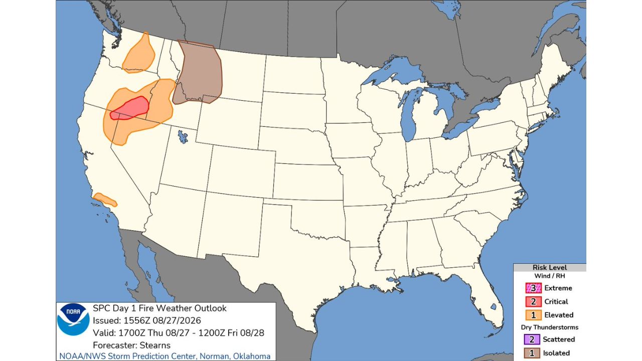
ALTURAS — The Storm Prediction Center issued a Critical Fire Weather designation for today, Thursday, August 27, covering far northeastern California and northwestern Nevada, with an Elevated Risk extending across a broader area of southeastern Oregon, northern California, and northern Nevada. The Day 1 Fire Weather Outlook, issued at 10:57 a.m. CDT, is valid from 12 p.m. CDT Thursday through 7 a.m. CDT Friday.

Dry Wind and Low Humidity Set Up a Dangerous Fire Weather Day

The Critical designation, the second-highest tier on the fire weather scale, is driven by a combination of strong winds and low relative humidity, conditions that allow existing fires to spread rapidly and make new ignitions far more likely to escalate. The critical zone sits directly over the border region of far northeastern California and northwestern Nevada, while the surrounding Elevated Risk area extends into southeastern Oregon and further into northern California and Nevada, reflecting a still-dangerous but somewhat lower level of wind and humidity concern.

Why Critical Fire Weather Ranks Above a Standard Red Flag Warning

A Critical fire weather designation from the Storm Prediction Center represents conditions capable of supporting extreme fire behavior, not just favorable conditions for ignition, but the kind of wind and dryness that can turn a small fire into a fast-moving, difficult-to-control blaze within hours. This designation typically prompts local National Weather Service offices to issue Red Flag Warnings for the affected counties, alerting residents and fire agencies that any spark, from equipment, vehicles, or lightning, carries elevated risk of rapid fire growth.

No Fires Confirmed Yet as the Critical Window Opens This Afternoon

As of this writing, this outlook reflects forecast fire weather conditions rather than any confirmed active fire activity tied to this specific critical designation. This article will be updated if new fire starts or fire weather-related incidents are reported within the outlined area.

How to Stay Safe During Critical Fire Weather

Before and during the critical window:

  • Avoid any outdoor activity that could spark a fire, including equipment use, campfires, or vehicle parking on dry grass
  • Have an evacuation plan ready, including a go-bag, if you live in or near the critical zone
  • Monitor local Red Flag Warnings, which are likely to accompany this SPC designation

If a fire starts nearby:

  • Leave early if authorities recommend evacuation, don’t wait until a fire is visible from your home
  • Stay informed through local emergency alerts rather than relying solely on visual smoke sightings

After the critical period passes:

  • Continue monitoring conditions, fire risk often remains elevated even after the most critical window closes
  • Report any unattended smoke or fire activity to local authorities immediately

A Familiar Late-Summer Threat Along the California-Nevada Border

Today’s Critical Fire Weather designation adds to what has been a recurring pattern across the California-Nevada-Oregon border region this fire season, where the combination of dry vegetation, low humidity, and gusty winds continues to create some of the most volatile fire weather conditions in the country during late summer.

For more coverage like this, check back for the latest severe weather updates.
Featured Articles

  • Twin Slight Risk Zones Explode Across Central Plains and NYC to Boston Corridor Today as Severe Storms Threaten Millions

    Twin Slight Risk Zones Explode Across Central Plains and NYC to Boston Corridor Today as Severe Storms Threaten Millions

    August 27, 2026
  • 60 MPH Winds and Isolated Tornado Threat Could Trigger Watch Across New York City Metro to Atlantic City by Early Afternoon

    60 MPH Winds and Isolated Tornado Threat Could Trigger Watch Across New York City Metro to Atlantic City by Early Afternoon

    August 27, 2026
  • Muggy 80 Degree Mornings Blur the Line Between Southern California and Florida as Heat Illness Risk Spikes

    Muggy 80 Degree Mornings Blur the Line Between Southern California and Florida as Heat Illness Risk Spikes

    August 27, 2026
  • Critical Fire Weather Conditions Target Far Northeastern California, Northwestern Nevada Today as Elevated Risk Spreads Into Oregon

    Critical Fire Weather Conditions Target Far Northeastern California, Northwestern Nevada Today as Elevated Risk Spreads Into Oregon

    August 27, 2026
  • Torrential Downpours and Strong Wind Gusts Take Aim at New York City Metro Within Two Hours as Storms Push North From Trenton

    Torrential Downpours and Strong Wind Gusts Take Aim at New York City Metro Within Two Hours as Storms Push North From Trenton

    August 27, 2026

Search

Follow Us on

  • Facebook
  • X
  • Instagram
  • VK
  • Pinterest
  • Last.fm
  • TikTok
  • Telegram
  • WhatsApp
  • RSS Feed

Categories

  • Forecast (50)

About Us

dulaneygriffin

Dulaney Griffin tracks storms, tornado risk, heat and snow across the United States, using National Weather Service and NOAA data. For active warnings in your area, always follow the National Weather Service and your local emergency officials.

Latest Articles

  • Twin Slight Risk Zones Explode Across Central Plains and NYC to Boston Corridor Today as Severe Storms Threaten Millions

    Twin Slight Risk Zones Explode Across Central Plains and NYC to Boston Corridor Today as Severe Storms Threaten Millions

    August 27, 2026
  • 60 MPH Winds and Isolated Tornado Threat Could Trigger Watch Across New York City Metro to Atlantic City by Early Afternoon

    60 MPH Winds and Isolated Tornado Threat Could Trigger Watch Across New York City Metro to Atlantic City by Early Afternoon

    August 27, 2026
  • Muggy 80 Degree Mornings Blur the Line Between Southern California and Florida as Heat Illness Risk Spikes

    Muggy 80 Degree Mornings Blur the Line Between Southern California and Florida as Heat Illness Risk Spikes

    August 27, 2026

Categories

  • Forecast (50)
  • Instagram
  • Facebook
  • LinkedIn
  • X
  • VK
  • TikTok

Proudly Powered by WordPress | JetNews Magazine by CozyThemes.

Scroll to Top