Skip to content

Home

About Us

Advertisement

Contact Us

  • Facebook
  • X
  • Instagram
  • Pinterest
  • WhatsApp
  • RSS Feed
  • TikTok

Dulaney Griffin

Your Trusted Weather Tracker.

Search

Huntsville and Florence, Alabama Faced Marginal Storm Risk Saturday Night as Arkansas Storms Eyed Northwest Alabama

Melissa Peel Avatar
Melissa Peel
August 23, 2026
Huntsville and Florence, Alabama Faced Marginal Storm Risk Saturday Night as Arkansas Storms Eyed Northwest Alabama

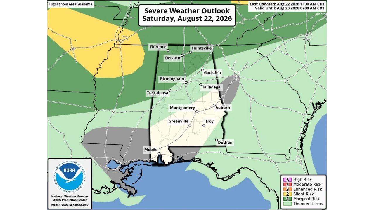
HUNTSVILLE — The Storm Prediction Center introduced a Marginal Risk (Level 1 of 5) of severe thunderstorms for late Saturday afternoon and overnight across north and west Alabama, generally for areas north of I-59, including Florence, Huntsville, Decatur and Birmingham. While most of the state stayed rain-free Saturday afternoon, high-resolution models suggested a mass of thunderstorms could form over Arkansas later in the day, then move into north Mississippi and northwest Alabama overnight.

  • Risk level: Marginal (1 of 5)
  • Highlighted area: north and west Alabama, generally north of I-59
  • Valid until: 7 a.m. CDT, Sunday, Aug. 23, 2026
  • Trigger: possible thunderstorm development over Arkansas, moving into north Mississippi and northwest Alabama
  • Hazard if storms form: strong wind gusts
  • Highest-risk window: roughly 8 p.m. to midnight Saturday night
  • Cities in the outlook: Florence, Huntsville, Decatur, Birmingham, Tuscaloosa, Gadsden

Why This Was a Conditional “If They Do Form” Threat

What set this outlook apart was its explicit uncertainty about whether storms would even develop at all. Rather than describing an active or highly probable system, the source specifically framed this as storms that “if they do form” could produce strong wind gusts, based on high-resolution model guidance rather than a confirmed, organized system already tracking toward Alabama. That conditional framing, combined with the low Marginal designation, meant residents in the Florence-to-Birmingham corridor were being given an early heads-up on a possible late-evening threat rather than a high-confidence forecast.

What Happened as the Overnight Window Passed

As of this writing, this outlook was valid through 7 a.m. Sunday, with the highest risk window identified as roughly 8 p.m. to midnight Saturday. No confirmed severe weather reports, wind damage, or storm activity tied to this outlook have been published in the data available. This article will be updated if confirmed storm reports or damage from Saturday night become available.

For more coverage like this, check back for the latest severe weather updates.

Featured Articles

  • Northern Great Basin, Gulf Coast and Maine Join Marginal Risk Zone as Monday’s Severe Outlook Expands

    Northern Great Basin, Gulf Coast and Maine Join Marginal Risk Zone as Monday’s Severe Outlook Expands

    August 23, 2026
  • Huntsville and Florence, Alabama Faced Marginal Storm Risk Saturday Night as Arkansas Storms Eyed Northwest Alabama

    Huntsville and Florence, Alabama Faced Marginal Storm Risk Saturday Night as Arkansas Storms Eyed Northwest Alabama

    August 23, 2026
  • Billings and Salt Lake City Face 75 MPH Wind Gust Threat as North and South Dakota Add Risk for 2-Inch Hail

    Billings and Salt Lake City Face 75 MPH Wind Gust Threat as North and South Dakota Add Risk for 2-Inch Hail

    August 23, 2026
  • Detroit and Cleveland Face Low-End Storm Risk Tonight as Exiting System Brings Final Round of Damaging Wind and Hail

    Detroit and Cleveland Face Low-End Storm Risk Tonight as Exiting System Brings Final Round of Damaging Wind and Hail

    August 23, 2026
  • Chicago and Springfield Get an Early Look at Wednesday Storm Potential as Quiet Stretch Nears Its End

    Chicago and Springfield Get an Early Look at Wednesday Storm Potential as Quiet Stretch Nears Its End

    August 23, 2026

Search

Follow Us on

  • Facebook
  • X
  • Instagram
  • VK
  • Pinterest
  • Last.fm
  • TikTok
  • Telegram
  • WhatsApp
  • RSS Feed

Categories

  • Forecast (25)

About Us

dulaneygriffin

Dulaney Griffin tracks storms, tornado risk, heat and snow across the United States, using National Weather Service and NOAA data. For active warnings in your area, always follow the National Weather Service and your local emergency officials.

Latest Articles

  • Northern Great Basin, Gulf Coast and Maine Join Marginal Risk Zone as Monday’s Severe Outlook Expands

    Northern Great Basin, Gulf Coast and Maine Join Marginal Risk Zone as Monday’s Severe Outlook Expands

    August 23, 2026
  • Huntsville and Florence, Alabama Faced Marginal Storm Risk Saturday Night as Arkansas Storms Eyed Northwest Alabama

    Huntsville and Florence, Alabama Faced Marginal Storm Risk Saturday Night as Arkansas Storms Eyed Northwest Alabama

    August 23, 2026
  • Billings and Salt Lake City Face 75 MPH Wind Gust Threat as North and South Dakota Add Risk for 2-Inch Hail

    Billings and Salt Lake City Face 75 MPH Wind Gust Threat as North and South Dakota Add Risk for 2-Inch Hail

    August 23, 2026

Categories

  • Forecast (25)
  • Instagram
  • Facebook
  • LinkedIn
  • X
  • VK
  • TikTok

Proudly Powered by WordPress | JetNews Magazine by CozyThemes.

Scroll to Top