Skip to content

Home

About Us

Advertisement

Contact Us

  • Facebook
  • X
  • Instagram
  • Pinterest
  • WhatsApp
  • RSS Feed
  • TikTok

Dulaney Griffin

Your Trusted Weather Tracker.

Search

Laredo and Tilden Hit 107 Degrees as South Texas Heat Index Climbs to 113 Under Sunny Skies

Melissa Peel Avatar
Melissa Peel
August 23, 2026
Laredo and Tilden Hit 107 Degrees as South Texas Heat Index Climbs to 113 Under Sunny Skies

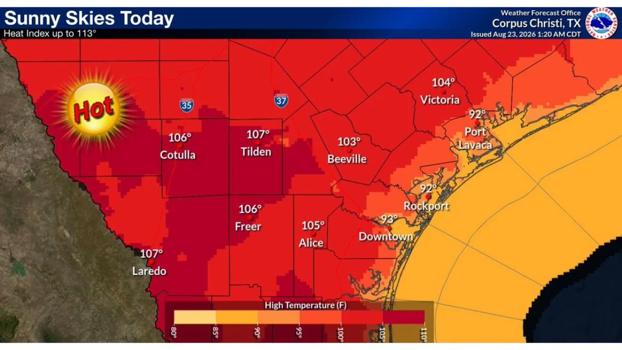
LAREDO — Sunny skies dominate South Texas Sunday, with highs reaching 100 to 107 degrees across the western half of the region and staying in the 90s closer to the coast. Heat index values climb as high as 113 degrees, with south to southeast winds of 10 to 20 mph doing little to offset the heat, according to the National Weather Service office in Corpus Christi.

The hottest readings cluster inland, with Laredo and Tilden both forecast to reach 107 degrees, followed closely by Cotulla and Freer at 106, and Alice and Beeville in the 103 to 105 range. Closer to the Gulf, temperatures ease into the 90s, with Port Lavaca and Rockport both expected near 92 to 93 degrees, and Victoria sitting higher at 104.

Why the Inland-to-Coast Temperature Split Matters

The roughly 15-degree gap between inland cities like Laredo and coastal communities like Port Lavaca reflects how much moderating influence the Gulf of Mexico has on temperatures even during an intense heat event like this one. That split matters practically: residents further inland across Webb, McMullen and Duval counties face genuinely more dangerous heat, with actual air temperatures alone approaching 107 degrees before factoring in humidity, while coastal residents see comparatively milder conditions, even if the heat index still climbs into oppressive territory closer to shore.

What to Watch For as Sunday’s Heat Peaks

As of this writing, this outlook was issued at 1:20 a.m. CDT and reflects Sunday’s expected conditions across South Texas. No heat advisories or excessive heat warnings specific to this outlook were included in the data provided. This article will be updated if the National Weather Service issues formal heat alerts or if conditions shift from this forecast.

For more coverage like this, check back for the latest severe weather updates.

Featured Articles

  • Northern Great Basin, Gulf Coast and Maine Join Marginal Risk Zone as Monday’s Severe Outlook Expands

    Northern Great Basin, Gulf Coast and Maine Join Marginal Risk Zone as Monday’s Severe Outlook Expands

    August 23, 2026
  • Huntsville and Florence, Alabama Faced Marginal Storm Risk Saturday Night as Arkansas Storms Eyed Northwest Alabama

    Huntsville and Florence, Alabama Faced Marginal Storm Risk Saturday Night as Arkansas Storms Eyed Northwest Alabama

    August 23, 2026
  • Billings and Salt Lake City Face 75 MPH Wind Gust Threat as North and South Dakota Add Risk for 2-Inch Hail

    Billings and Salt Lake City Face 75 MPH Wind Gust Threat as North and South Dakota Add Risk for 2-Inch Hail

    August 23, 2026
  • Detroit and Cleveland Face Low-End Storm Risk Tonight as Exiting System Brings Final Round of Damaging Wind and Hail

    Detroit and Cleveland Face Low-End Storm Risk Tonight as Exiting System Brings Final Round of Damaging Wind and Hail

    August 23, 2026
  • Chicago and Springfield Get an Early Look at Wednesday Storm Potential as Quiet Stretch Nears Its End

    Chicago and Springfield Get an Early Look at Wednesday Storm Potential as Quiet Stretch Nears Its End

    August 23, 2026

Search

Follow Us on

  • Facebook
  • X
  • Instagram
  • VK
  • Pinterest
  • Last.fm
  • TikTok
  • Telegram
  • WhatsApp
  • RSS Feed

Categories

  • Forecast (25)

About Us

dulaneygriffin

Dulaney Griffin tracks storms, tornado risk, heat and snow across the United States, using National Weather Service and NOAA data. For active warnings in your area, always follow the National Weather Service and your local emergency officials.

Latest Articles

  • Northern Great Basin, Gulf Coast and Maine Join Marginal Risk Zone as Monday’s Severe Outlook Expands

    Northern Great Basin, Gulf Coast and Maine Join Marginal Risk Zone as Monday’s Severe Outlook Expands

    August 23, 2026
  • Huntsville and Florence, Alabama Faced Marginal Storm Risk Saturday Night as Arkansas Storms Eyed Northwest Alabama

    Huntsville and Florence, Alabama Faced Marginal Storm Risk Saturday Night as Arkansas Storms Eyed Northwest Alabama

    August 23, 2026
  • Billings and Salt Lake City Face 75 MPH Wind Gust Threat as North and South Dakota Add Risk for 2-Inch Hail

    Billings and Salt Lake City Face 75 MPH Wind Gust Threat as North and South Dakota Add Risk for 2-Inch Hail

    August 23, 2026

Categories

  • Forecast (25)
  • Instagram
  • Facebook
  • LinkedIn
  • X
  • VK
  • TikTok

Proudly Powered by WordPress | JetNews Magazine by CozyThemes.

Scroll to Top