Skip to content

Home

About Us

Advertisement

Contact Us

  • Facebook
  • X
  • Instagram
  • Pinterest
  • WhatsApp
  • RSS Feed
  • TikTok

Dulaney Griffin

Your Trusted Weather Tracker.

Search

Indianapolis and Columbus Finally Catch a Break as Rain Chances Turn Isolated Across the Ohio Valley Next Week

Melissa Peel Avatar
Melissa Peel
August 23, 2026
Indianapolis and Columbus Finally Catch a Break as Rain Chances Turn Isolated Across the Ohio Valley Next Week

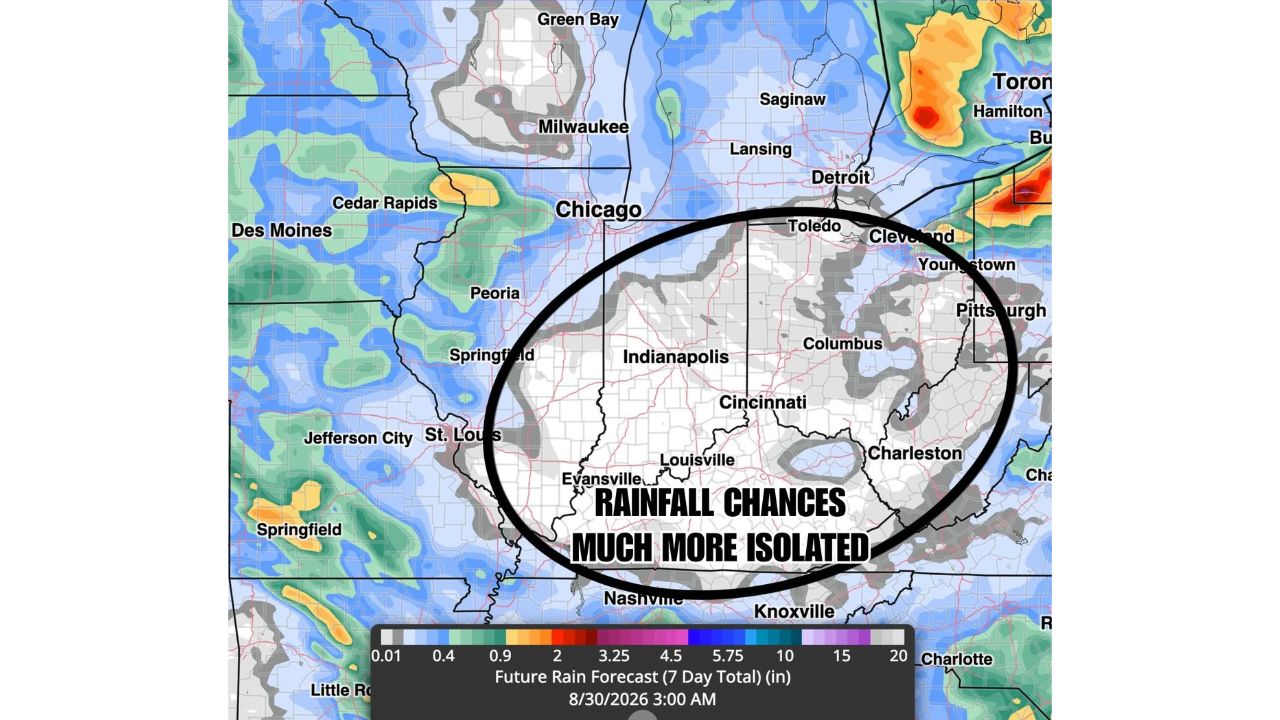
INDIANAPOLIS — After weeks of repeated flooding and heavy rain across the Ohio Valley, forecasters say a genuine break is on the way, with rainfall chances turning much more isolated across a corridor from Indianapolis through Columbus and down to Louisville and Cincinnati over the coming seven days, running from Aug. 23 through Aug. 30.

Rain chances remain hit or miss across the broader Ohio Valley, and forecasters caution that observed rainfall will likely verify messier than a clean forecast map suggests. Even so, the driest stretch on the seven-day outlook lands squarely over the Indianapolis-to-Columbus corridor, an area that’s absorbed some of the heaviest, most repetitive rain in the region over recent weeks.

Why “Messier” Doesn’t Mean the Break Isn’t Real

Forecasters specifically flagged that this outlook won’t play out as cleanly as the map implies, rain across the Ohio Valley in this pattern tends to be scattered and inconsistent rather than falling uniformly. That caveat matters because it means some spots within the broader region could still see occasional rain even as the overall trend shifts drier. What doesn’t change is the core signal: the corridor most in need of a break, Indianapolis through Columbus, sits at the center of the driest zone on the forecast, suggesting even accounting for messier day-to-day details, the overall week ahead should look meaningfully different from the saturated pattern the region has been stuck in.

What This Means for an Already Saturated Region

For communities that have spent recent weeks watching rivers run high and ground stay saturated, a week of largely isolated rainfall gives the ground genuine time to recover rather than facing another round of compounding flood risk. As of this writing, this remains a seven-day forecast outlook rather than a guarantee, and conditions could shift as the week progresses. This article will be updated if the outlook changes significantly in either direction.

For more coverage like this, check back for the latest severe weather updates.

Featured Articles

  • Northern Great Basin, Gulf Coast and Maine Join Marginal Risk Zone as Monday’s Severe Outlook Expands

    Northern Great Basin, Gulf Coast and Maine Join Marginal Risk Zone as Monday’s Severe Outlook Expands

    August 23, 2026
  • Huntsville and Florence, Alabama Faced Marginal Storm Risk Saturday Night as Arkansas Storms Eyed Northwest Alabama

    Huntsville and Florence, Alabama Faced Marginal Storm Risk Saturday Night as Arkansas Storms Eyed Northwest Alabama

    August 23, 2026
  • Billings and Salt Lake City Face 75 MPH Wind Gust Threat as North and South Dakota Add Risk for 2-Inch Hail

    Billings and Salt Lake City Face 75 MPH Wind Gust Threat as North and South Dakota Add Risk for 2-Inch Hail

    August 23, 2026
  • Detroit and Cleveland Face Low-End Storm Risk Tonight as Exiting System Brings Final Round of Damaging Wind and Hail

    Detroit and Cleveland Face Low-End Storm Risk Tonight as Exiting System Brings Final Round of Damaging Wind and Hail

    August 23, 2026
  • Chicago and Springfield Get an Early Look at Wednesday Storm Potential as Quiet Stretch Nears Its End

    Chicago and Springfield Get an Early Look at Wednesday Storm Potential as Quiet Stretch Nears Its End

    August 23, 2026

Search

Follow Us on

  • Facebook
  • X
  • Instagram
  • VK
  • Pinterest
  • Last.fm
  • TikTok
  • Telegram
  • WhatsApp
  • RSS Feed

Categories

  • Forecast (25)

About Us

dulaneygriffin

Dulaney Griffin tracks storms, tornado risk, heat and snow across the United States, using National Weather Service and NOAA data. For active warnings in your area, always follow the National Weather Service and your local emergency officials.

Latest Articles

  • Northern Great Basin, Gulf Coast and Maine Join Marginal Risk Zone as Monday’s Severe Outlook Expands

    Northern Great Basin, Gulf Coast and Maine Join Marginal Risk Zone as Monday’s Severe Outlook Expands

    August 23, 2026
  • Huntsville and Florence, Alabama Faced Marginal Storm Risk Saturday Night as Arkansas Storms Eyed Northwest Alabama

    Huntsville and Florence, Alabama Faced Marginal Storm Risk Saturday Night as Arkansas Storms Eyed Northwest Alabama

    August 23, 2026
  • Billings and Salt Lake City Face 75 MPH Wind Gust Threat as North and South Dakota Add Risk for 2-Inch Hail

    Billings and Salt Lake City Face 75 MPH Wind Gust Threat as North and South Dakota Add Risk for 2-Inch Hail

    August 23, 2026

Categories

  • Forecast (25)
  • Instagram
  • Facebook
  • LinkedIn
  • X
  • VK
  • TikTok

Proudly Powered by WordPress | JetNews Magazine by CozyThemes.

Scroll to Top