Skip to content

Home

About Us

Advertisement

Contact Us

  • Facebook
  • X
  • Instagram
  • Pinterest
  • WhatsApp
  • RSS Feed
  • TikTok

Dulaney Griffin

Your Trusted Weather Tracker.

Search

Burns, Lakeview and Susanville Face Critical Fire Danger Saturday as 25 MPH Winds and 15 Percent Humidity Return to the Northwest

Melissa Peel Avatar
Melissa Peel
August 21, 2026
Burns, Lakeview and Susanville Face Critical Fire Danger Saturday as 25 MPH Winds and 15 Percent Humidity Return to the Northwest

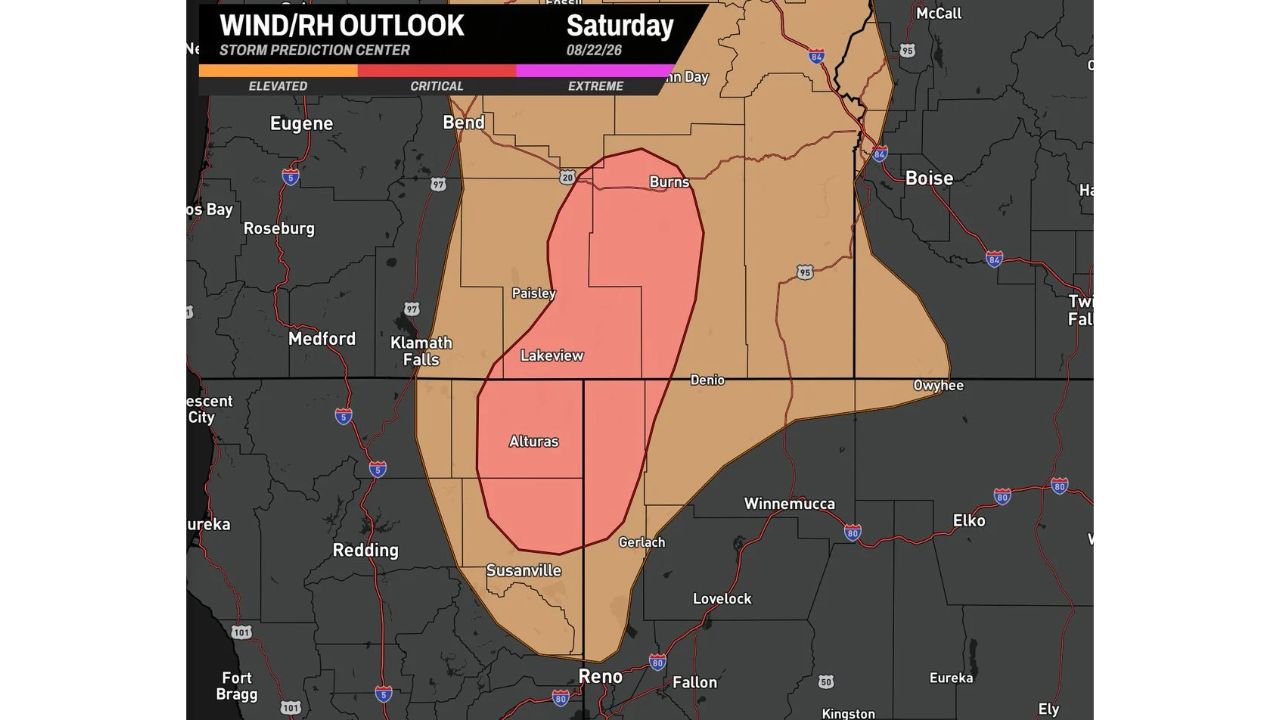
BURNS, Ore. — Critical fire danger returns to the Northwest Saturday, with a corridor stretching from Bend and Burns, Oregon south through Lakeview, Alturas and Susanville, California facing strong sustained winds of 20 to 25 mph, relative humidity dropping to around 15 percent, and very dry fuels, conditions capable of letting any new fire spread rapidly. A broader Elevated Risk zone surrounds the Critical area, stretching from Eugene and Medford through Boise and Winnemucca.

The Critical zone forms a narrow band centered on Paisley, Lakeview and Alturas, with a smaller pocket also flagged near Burns. Forecasters warned the same corridor could see similar conditions repeat on Sunday, meaning this isn’t a single-day concern but the start of a multi-day stretch of dangerous fire weather.

Why This Combination of Numbers Matters

Individually, 20 to 25 mph winds or 15 percent humidity wouldn’t necessarily push an area into Critical fire danger. It’s the combination, strong sustained wind feeding oxygen to any flame while bone-dry air and already-dry fuels offer little resistance, that creates conditions where a fire, once started, can outrun containment efforts before crews even arrive. That’s the specific danger behind the Critical designation: not that a fire is more likely to start, but that if one does, it has almost nothing standing in the way of rapid spread.

What to Watch For Through the Weekend

As of this writing, this is a Day 1 wind/relative humidity outlook issued ahead of Saturday’s conditions, not confirmation of an active wildfire. No red flag warnings or confirmed fire activity tied to this specific outlook have been published. With similar conditions expected to return Sunday, this article will be updated if the risk area shifts or if fire activity develops.

Avoid outdoor burning or any activity that could spark a fire if you’re anywhere in the highlighted corridor heading into the weekend, forecasters specifically warned, given how quickly conditions like these can turn a small spark into an uncontrollable fire.

For more coverage like this, check back for the latest severe weather updates.
Featured Articles

  • Burns, Lakeview and Susanville Face Critical Fire Danger Saturday as 25 MPH Winds and 15 Percent Humidity Return to the Northwest

    Burns, Lakeview and Susanville Face Critical Fire Danger Saturday as 25 MPH Winds and 15 Percent Humidity Return to the Northwest

    August 21, 2026
  • Washington, Rockville and Baltimore Watch Sub-Severe Storm Line Approach as Warnings Possible Over Next Two Hours

    Washington, Rockville and Baltimore Watch Sub-Severe Storm Line Approach as Warnings Possible Over Next Two Hours

    August 21, 2026
  • Davenport to Milwaukee Face Quick Tornado Risk This Afternoon as Scattered Storms Develop Across Southern Wisconsin and Northern Illinois

    Davenport to Milwaukee Face Quick Tornado Risk This Afternoon as Scattered Storms Develop Across Southern Wisconsin and Northern Illinois

    August 21, 2026
  • Scattered Coastal Storms Develop Across North Carolina Including Jacksonville Wilmington and Central NC With Gusty Winds and Heavy Rainfall This Afternoon Evening

    Scattered Coastal Storms Develop Across North Carolina Including Jacksonville Wilmington and Central NC With Gusty Winds and Heavy Rainfall This Afternoon Evening

    August 21, 2026
  • Extreme Heat Warning Blankets Louisiana Along With Parts of Texas Arkansas and Mississippi as Dangerous Conditions Grip the Entire Gulf Coast Region

    Extreme Heat Warning Blankets Louisiana Along With Parts of Texas Arkansas and Mississippi as Dangerous Conditions Grip the Entire Gulf Coast Region

    August 21, 2026

Search

Follow Us on

  • Facebook
  • X
  • Instagram
  • VK
  • Pinterest
  • Last.fm
  • TikTok
  • Telegram
  • WhatsApp
  • RSS Feed

Categories

  • Forecast (8)

About Us

dulaneygriffin

Dulaney Griffin tracks storms, tornado risk, heat and snow across the United States, using National Weather Service and NOAA data. For active warnings in your area, always follow the National Weather Service and your local emergency officials.

Latest Articles

  • Burns, Lakeview and Susanville Face Critical Fire Danger Saturday as 25 MPH Winds and 15 Percent Humidity Return to the Northwest

    Burns, Lakeview and Susanville Face Critical Fire Danger Saturday as 25 MPH Winds and 15 Percent Humidity Return to the Northwest

    August 21, 2026
  • Washington, Rockville and Baltimore Watch Sub-Severe Storm Line Approach as Warnings Possible Over Next Two Hours

    Washington, Rockville and Baltimore Watch Sub-Severe Storm Line Approach as Warnings Possible Over Next Two Hours

    August 21, 2026
  • Davenport to Milwaukee Face Quick Tornado Risk This Afternoon as Scattered Storms Develop Across Southern Wisconsin and Northern Illinois

    Davenport to Milwaukee Face Quick Tornado Risk This Afternoon as Scattered Storms Develop Across Southern Wisconsin and Northern Illinois

    August 21, 2026

Categories

  • Forecast (8)
  • Instagram
  • Facebook
  • LinkedIn
  • X
  • VK
  • TikTok

Proudly Powered by WordPress | JetNews Magazine by CozyThemes.

Scroll to Top