Skip to content

Home

About Us

Advertisement

Contact Us

  • Facebook
  • X
  • Instagram
  • Pinterest
  • WhatsApp
  • RSS Feed
  • TikTok

Dulaney Griffin

Your Trusted Weather Tracker.

Search

Severe Thunderstorm Threat Climbs for Northern Ohio Including Cleveland and Akron Saturday as High CAPE Values and Strong Wind Shear Align Perfectly

Melissa Peel Avatar
Melissa Peel
August 21, 2026
Severe Thunderstorm Threat Climbs for Northern Ohio Including Cleveland and Akron Saturday as High CAPE Values and Strong Wind Shear Align Perfectly

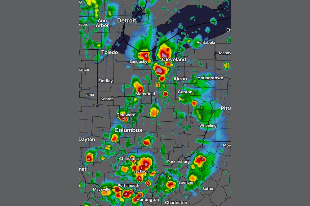
NORTHERN OHIO — The severe thunderstorm threat continues to climb for Saturday across northern Ohio, with the latest model runs trending stronger as key ingredients line up almost perfectly. Storm timing now aligns with peak afternoon heating, and guidance continues to push instability higher. CAPE values near 3,000 J/kg, paired with 35 knots of wind shear, represent a legitimate severe weather setup for the region, including areas around Cleveland, Akron, and Canton.

Strong Instability and Shear Combine for a Legitimate Severe Setup

Forecasters say the combination of high CAPE values and strong wind shear creates the kind of environment capable of supporting organized severe thunderstorms once initiation occurs Saturday.

With storm timing lining up directly with peak afternoon heating, instability is expected to be at its highest just as the atmosphere becomes primed for development.

Weak Cap Should Allow Storms to Fire Without Difficulty

A very weak to nearly nonexistent cap is in place, meaning the incoming frontal boundary should have no trouble firing storms once it arrives Saturday afternoon.

This lack of a capping inversion increases confidence that widespread storm development will occur rather than isolated or suppressed activity across the threat zone.

Fresh Severe Outlook Expected Later Saturday

An updated severe outlook map was expected to be released later Saturday afternoon as forecasters continue refining the placement and intensity of the threat.

Communities across northern Ohio, including the Cleveland and Akron metro areas, are encouraged to stay weather aware as confidence in a significant severe setup continues to grow.


Featured Articles

  • Burns, Lakeview and Susanville Face Critical Fire Danger Saturday as 25 MPH Winds and 15 Percent Humidity Return to the Northwest

    Burns, Lakeview and Susanville Face Critical Fire Danger Saturday as 25 MPH Winds and 15 Percent Humidity Return to the Northwest

    August 21, 2026
  • Washington, Rockville and Baltimore Watch Sub-Severe Storm Line Approach as Warnings Possible Over Next Two Hours

    Washington, Rockville and Baltimore Watch Sub-Severe Storm Line Approach as Warnings Possible Over Next Two Hours

    August 21, 2026
  • Davenport to Milwaukee Face Quick Tornado Risk This Afternoon as Scattered Storms Develop Across Southern Wisconsin and Northern Illinois

    Davenport to Milwaukee Face Quick Tornado Risk This Afternoon as Scattered Storms Develop Across Southern Wisconsin and Northern Illinois

    August 21, 2026
  • Scattered Coastal Storms Develop Across North Carolina Including Jacksonville Wilmington and Central NC With Gusty Winds and Heavy Rainfall This Afternoon Evening

    Scattered Coastal Storms Develop Across North Carolina Including Jacksonville Wilmington and Central NC With Gusty Winds and Heavy Rainfall This Afternoon Evening

    August 21, 2026
  • Extreme Heat Warning Blankets Louisiana Along With Parts of Texas Arkansas and Mississippi as Dangerous Conditions Grip the Entire Gulf Coast Region

    Extreme Heat Warning Blankets Louisiana Along With Parts of Texas Arkansas and Mississippi as Dangerous Conditions Grip the Entire Gulf Coast Region

    August 21, 2026

Search

Follow Us on

  • Facebook
  • X
  • Instagram
  • VK
  • Pinterest
  • Last.fm
  • TikTok
  • Telegram
  • WhatsApp
  • RSS Feed

Categories

  • Forecast (8)

About Us

dulaneygriffin

Dulaney Griffin tracks storms, tornado risk, heat and snow across the United States, using National Weather Service and NOAA data. For active warnings in your area, always follow the National Weather Service and your local emergency officials.

Latest Articles

  • Burns, Lakeview and Susanville Face Critical Fire Danger Saturday as 25 MPH Winds and 15 Percent Humidity Return to the Northwest

    Burns, Lakeview and Susanville Face Critical Fire Danger Saturday as 25 MPH Winds and 15 Percent Humidity Return to the Northwest

    August 21, 2026
  • Washington, Rockville and Baltimore Watch Sub-Severe Storm Line Approach as Warnings Possible Over Next Two Hours

    Washington, Rockville and Baltimore Watch Sub-Severe Storm Line Approach as Warnings Possible Over Next Two Hours

    August 21, 2026
  • Davenport to Milwaukee Face Quick Tornado Risk This Afternoon as Scattered Storms Develop Across Southern Wisconsin and Northern Illinois

    Davenport to Milwaukee Face Quick Tornado Risk This Afternoon as Scattered Storms Develop Across Southern Wisconsin and Northern Illinois

    August 21, 2026

Categories

  • Forecast (8)
  • Instagram
  • Facebook
  • LinkedIn
  • X
  • VK
  • TikTok

Proudly Powered by WordPress | JetNews Magazine by CozyThemes.

Scroll to Top