Skip to content

Home

About Us

Advertisement

Contact Us

  • Facebook
  • X
  • Instagram
  • Pinterest
  • WhatsApp
  • RSS Feed
  • TikTok

Dulaney Griffin

Your Trusted Weather Tracker.

Search

Cleveland, Columbus and Pittsburgh Sit Under “Possible” Tag as Saturday’s Damaging Wind Threat Gets a Likelihood Label

Melissa Peel Avatar
Melissa Peel
August 22, 2026
Cleveland, Columbus and Pittsburgh Sit Under “Possible” Tag as Saturday’s Damaging Wind Threat Gets a Likelihood Label

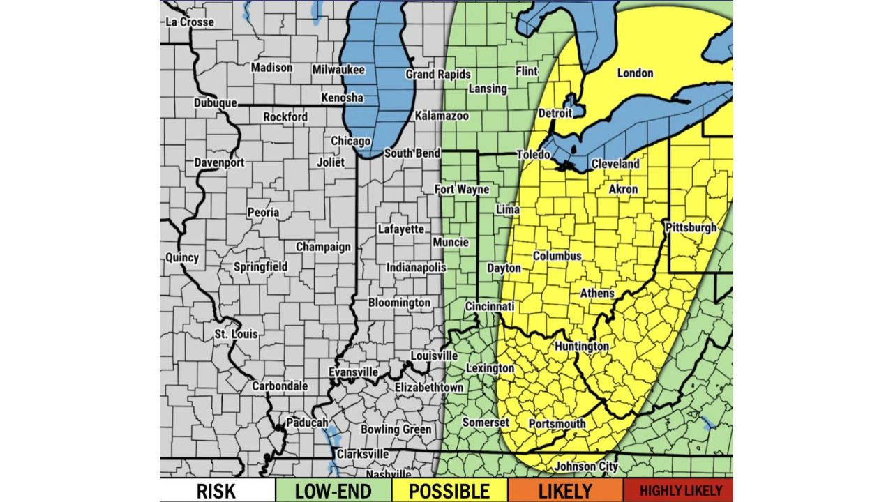
COLUMBUS — Scattered strong to severe storms are anticipated to develop this afternoon and evening across the eastern half of the Ohio Valley, with damaging winds and isolated large hail remaining the main concerns. Unlike a standard risk map, this outlook assigns a specific likelihood label to the threat: a “Possible” tag covers a band running from Toledo and Detroit south through Cleveland, Akron, Columbus, Athens and down to Huntington and Portsmouth, with a lower “Low-End” risk bordering it to the west through South Bend, Fort Wayne and Indianapolis.

The Possible zone forms a wide vertical band roughly following the Ohio-Michigan-Pennsylvania corridor, while cities further west like Chicago, Peoria and St. Louis fall entirely outside any highlighted risk area on this particular outlook.

Why a “Possible” Label Reads Differently Than a Percentage

Instead of a numeric probability, this outlook uses plain-language likelihood tiers, Low-End, Possible, Likely and Highly Likely, to communicate risk. A “Possible” designation sits in the middle of that scale, below Likely and Highly Likely but above the baseline Low-End category, giving residents in cities like Columbus, Cleveland and Pittsburgh a more intuitive read on how confident forecasters are compared to a bare percentage figure. For this outlook, no part of the map reached the Likely or Highly Likely tiers, meaning even the highest-confidence zone still falls short of a near-certain forecast.

What to Watch For This Afternoon and Evening

As of this writing, this is a forecast outlook for Saturday afternoon and evening, not a confirmed watch or warning. No severe thunderstorm watches tied to this specific outlook have been issued yet. This article will be updated as watches, warnings, or storm reports develop across the Ohio Valley through the evening.

For more coverage like this, check back for the latest severe weather updates.

Featured Articles

  • Rapid City and the Central High Plains Face Marginal Severe Threat Monday as Storm Prediction Center Looks Three Days Ahead

    Rapid City and the Central High Plains Face Marginal Severe Threat Monday as Storm Prediction Center Looks Three Days Ahead

    August 22, 2026
  • Below-Average Temperatures Bring Welcome Break From the Heat as Cooler Air Settles Over Chicago, Columbus and the Ohio Valley

    Below-Average Temperatures Bring Welcome Break From the Heat as Cooler Air Settles Over Chicago, Columbus and the Ohio Valley

    August 22, 2026
  • Concordia and Northeast Kansas Brace for 50 MPH Wind Gusts as Nebraska Storms Push South This Morning

    Concordia and Northeast Kansas Brace for 50 MPH Wind Gusts as Nebraska Storms Push South This Morning

    August 22, 2026
  • Central Oklahoma and South-Central Kansas Face Localized Flash Flood Risk as Storms Repeat Over Same Ground

    Central Oklahoma and South-Central Kansas Face Localized Flash Flood Risk as Storms Repeat Over Same Ground

    August 22, 2026
  • Purcell and Slaughterville, Oklahoma Face Ping Pong Ball Hail as 70 MPH Storm Continues Overnight

    Purcell and Slaughterville, Oklahoma Face Ping Pong Ball Hail as 70 MPH Storm Continues Overnight

    August 22, 2026

Search

Follow Us on

  • Facebook
  • X
  • Instagram
  • VK
  • Pinterest
  • Last.fm
  • TikTok
  • Telegram
  • WhatsApp
  • RSS Feed

Categories

  • Forecast (17)

About Us

dulaneygriffin

Dulaney Griffin tracks storms, tornado risk, heat and snow across the United States, using National Weather Service and NOAA data. For active warnings in your area, always follow the National Weather Service and your local emergency officials.

Latest Articles

  • Rapid City and the Central High Plains Face Marginal Severe Threat Monday as Storm Prediction Center Looks Three Days Ahead

    Rapid City and the Central High Plains Face Marginal Severe Threat Monday as Storm Prediction Center Looks Three Days Ahead

    August 22, 2026
  • Below-Average Temperatures Bring Welcome Break From the Heat as Cooler Air Settles Over Chicago, Columbus and the Ohio Valley

    Below-Average Temperatures Bring Welcome Break From the Heat as Cooler Air Settles Over Chicago, Columbus and the Ohio Valley

    August 22, 2026
  • Concordia and Northeast Kansas Brace for 50 MPH Wind Gusts as Nebraska Storms Push South This Morning

    Concordia and Northeast Kansas Brace for 50 MPH Wind Gusts as Nebraska Storms Push South This Morning

    August 22, 2026

Categories

  • Forecast (17)
  • Instagram
  • Facebook
  • LinkedIn
  • X
  • VK
  • TikTok

Proudly Powered by WordPress | JetNews Magazine by CozyThemes.

Scroll to Top