Skip to content

Home

About Us

Advertisement

Contact Us

  • Facebook
  • X
  • Instagram
  • Pinterest
  • WhatsApp
  • RSS Feed
  • TikTok

Dulaney Griffin

Your Trusted Weather Tracker.

Search

Cleveland, Columbus and Lexington Face Another Round of Strong to Severe Storms With Isolated Tornado Not Ruled Out

Melissa Peel Avatar
Melissa Peel
August 22, 2026
Cleveland, Columbus and Lexington Face Another Round of Strong to Severe Storms With Isolated Tornado Not Ruled Out

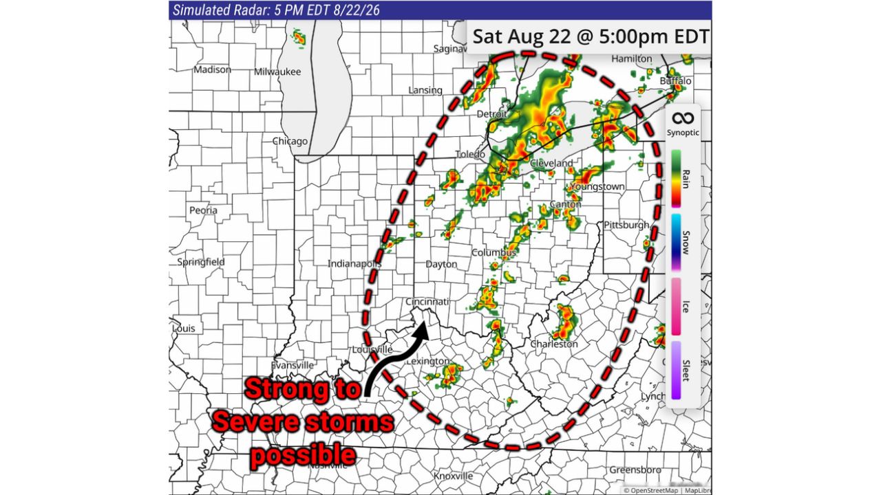
COLUMBUS — Yet another round of storms is expected across much of Ohio and eastern Kentucky this afternoon into evening, with damaging gusts and large hail the main concerns as strong to severe storms track through a corridor from Detroit and Cleveland south through Columbus, Dayton and down to Lexington. Forecasters added a detail not flagged in earlier outlooks for the day: an isolated tornado cannot be ruled out.

Simulated radar for 5 p.m. EDT showed storms already active in a band curving from near Toledo and Cleveland south through Canton, Youngstown and down through Columbus toward Cincinnati and Lexington, with the heaviest cells clustered around the Columbus-to-Dayton stretch.

Why the Tornado Caveat Matters on Top of Wind and Hail

Storm setups built primarily around damaging gusts and large hail don’t always carry meaningful tornado potential, so specifically flagging that an isolated tornado cannot be ruled out signals forecasters see enough rotation potential within these storms to warrant extra caution, even though it isn’t the headline threat. For residents across the Ohio and eastern Kentucky corridor, that means today’s storms carry a broader range of possible outcomes than a standard wind-and-hail event, warranting the same shelter response as a more classic tornado setup if warnings are issued.

What to Watch For This Afternoon and Evening

As of this writing, storms were already visible on radar as of 5 p.m. EDT, tracking through the highlighted corridor from Detroit to Lexington. No confirmed severe weather reports, tornado touchdowns, or damage tied to this round have been published. This article will be updated as warnings are issued or confirmed storm reports come in through the evening.

For more coverage like this, check back for the latest severe weather updates.

Featured Articles

  • Rapid City and the Central High Plains Face Marginal Severe Threat Monday as Storm Prediction Center Looks Three Days Ahead

    Rapid City and the Central High Plains Face Marginal Severe Threat Monday as Storm Prediction Center Looks Three Days Ahead

    August 22, 2026
  • Below-Average Temperatures Bring Welcome Break From the Heat as Cooler Air Settles Over Chicago, Columbus and the Ohio Valley

    Below-Average Temperatures Bring Welcome Break From the Heat as Cooler Air Settles Over Chicago, Columbus and the Ohio Valley

    August 22, 2026
  • Concordia and Northeast Kansas Brace for 50 MPH Wind Gusts as Nebraska Storms Push South This Morning

    Concordia and Northeast Kansas Brace for 50 MPH Wind Gusts as Nebraska Storms Push South This Morning

    August 22, 2026
  • Central Oklahoma and South-Central Kansas Face Localized Flash Flood Risk as Storms Repeat Over Same Ground

    Central Oklahoma and South-Central Kansas Face Localized Flash Flood Risk as Storms Repeat Over Same Ground

    August 22, 2026
  • Purcell and Slaughterville, Oklahoma Face Ping Pong Ball Hail as 70 MPH Storm Continues Overnight

    Purcell and Slaughterville, Oklahoma Face Ping Pong Ball Hail as 70 MPH Storm Continues Overnight

    August 22, 2026

Search

Follow Us on

  • Facebook
  • X
  • Instagram
  • VK
  • Pinterest
  • Last.fm
  • TikTok
  • Telegram
  • WhatsApp
  • RSS Feed

Categories

  • Forecast (17)

About Us

dulaneygriffin

Dulaney Griffin tracks storms, tornado risk, heat and snow across the United States, using National Weather Service and NOAA data. For active warnings in your area, always follow the National Weather Service and your local emergency officials.

Latest Articles

  • Rapid City and the Central High Plains Face Marginal Severe Threat Monday as Storm Prediction Center Looks Three Days Ahead

    Rapid City and the Central High Plains Face Marginal Severe Threat Monday as Storm Prediction Center Looks Three Days Ahead

    August 22, 2026
  • Below-Average Temperatures Bring Welcome Break From the Heat as Cooler Air Settles Over Chicago, Columbus and the Ohio Valley

    Below-Average Temperatures Bring Welcome Break From the Heat as Cooler Air Settles Over Chicago, Columbus and the Ohio Valley

    August 22, 2026
  • Concordia and Northeast Kansas Brace for 50 MPH Wind Gusts as Nebraska Storms Push South This Morning

    Concordia and Northeast Kansas Brace for 50 MPH Wind Gusts as Nebraska Storms Push South This Morning

    August 22, 2026

Categories

  • Forecast (17)
  • Instagram
  • Facebook
  • LinkedIn
  • X
  • VK
  • TikTok

Proudly Powered by WordPress | JetNews Magazine by CozyThemes.

Scroll to Top