Skip to content

Home

About Us

Advertisement

Contact Us

  • Facebook
  • X
  • Instagram
  • Pinterest
  • WhatsApp
  • RSS Feed
  • TikTok

Dulaney Griffin

Your Trusted Weather Tracker.

Search

Akron, Columbus and Cleveland Face Level 2 Damaging Wind Threat Today as 16.8 Million People Sit in Path of Afternoon Storm Clusters

Melissa Peel Avatar
Melissa Peel
August 22, 2026
Akron, Columbus and Cleveland Face Level 2 Damaging Wind Threat Today as 16.8 Million People Sit in Path of Afternoon Storm Clusters

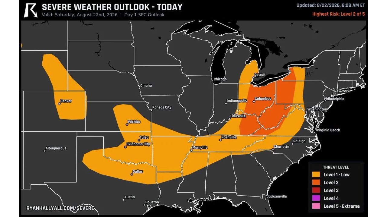
COLUMBUS — A Level 2 severe weather risk targets damaging wind across Ohio, West Virginia and into the Appalachians Saturday, putting roughly 16.8 million people in the zone as a weak front pushes storm clusters through the region this afternoon. Wind gusts are the main story, though forecasters noted some hail is possible too.

Timing splits by city. Akron and Cleveland look busiest right around 2 p.m., while Columbus, sitting further south along the same corridor, sees its activity ramp up about an hour later, near 3 p.m. The Level 2 zone forms a tight band running roughly from Detroit south through Columbus and down toward Louisville, with a much larger surrounding Level 1 area stretching from Denver and Oklahoma City through Nashville, Charlotte and up to Washington, D.C.

Why the One-Hour Gap Between Cities Matters

A weak front pushing storm clusters through in sequence, rather than a single line arriving everywhere at once, means the Akron-to-Cleveland corridor and the Columbus area face genuinely different windows for their worst conditions. That roughly one-hour gap gives forecasters a useful marker: residents further north should be watching closely as 2 p.m. approaches, while those around Columbus have a bit more runway before the same storm clusters reach them closer to 3 p.m.

What to Watch For This Afternoon

As of this writing, this is a Day 1 outlook with the day’s severe weather still ahead across the highlighted corridor. No severe thunderstorm watches tied to the Ohio, West Virginia and Appalachians zone have been issued yet. This article will be updated as watches, warnings, or storm reports develop through the afternoon, particularly as the 2 p.m. and 3 p.m. windows for Akron/Cleveland and Columbus approach.

For more coverage like this, check back for the latest severe weather updates.

Featured Articles

  • Police Say Two Young Passengers Are in Critical Condition After a Crash Near Sherman Boulevard and Silver Spring Drive on Milwaukee’s North Side Wednesday Night

    Police Say Two Young Passengers Are in Critical Condition After a Crash Near Sherman Boulevard and Silver Spring Drive on Milwaukee’s North Side Wednesday Night

    September 5, 2026
  • Kenosha Man Charged After Glendale Police Chase Ends in Fox Point Crash That Hurt a 1-Year-Old Child and Reached 97 Mph

    Kenosha Man Charged After Glendale Police Chase Ends in Fox Point Crash That Hurt a 1-Year-Old Child and Reached 97 Mph

    September 5, 2026
  • Pickup Truck Crashes Into Pennsylvania State Police Barracks in Cherry Ridge Township, Injuring Officer and Leaving Honesdale Station Communications Disrupted

    Pickup Truck Crashes Into Pennsylvania State Police Barracks in Cherry Ridge Township, Injuring Officer and Leaving Honesdale Station Communications Disrupted

    September 5, 2026
  • Honesdale Man Accused of Crashing Beer Filled Pickup Into Pennsylvania State Police Station, Injuring Communications Officer and Telling Trooper He Was Drunk

    Honesdale Man Accused of Crashing Beer Filled Pickup Into Pennsylvania State Police Station, Injuring Communications Officer and Telling Trooper He Was Drunk

    September 5, 2026
  • UW-Madison Police Investigate Three Reported Sexual Assaults on Campus in Two Weeks, Including a Recent Southeast Residence Hall Case and Charges in Another Attack

    UW-Madison Police Investigate Three Reported Sexual Assaults on Campus in Two Weeks, Including a Recent Southeast Residence Hall Case and Charges in Another Attack

    September 5, 2026

Search

Follow Us on

  • Facebook
  • X
  • Instagram
  • VK
  • Pinterest
  • Last.fm
  • TikTok
  • Telegram
  • WhatsApp
  • RSS Feed

Categories

  • Crash Board (15)
  • Forecast (68)
  • Last Seen (3)
  • Sheriff's Log (12)

About Us

dulaneygriffin

Dulaney Griffin tracks storms, tornado risk, heat and snow across the United States, using National Weather Service and NOAA data. For active warnings in your area, always follow the National Weather Service and your local emergency officials.

Latest Articles

  • Police Say Two Young Passengers Are in Critical Condition After a Crash Near Sherman Boulevard and Silver Spring Drive on Milwaukee’s North Side Wednesday Night

    Police Say Two Young Passengers Are in Critical Condition After a Crash Near Sherman Boulevard and Silver Spring Drive on Milwaukee’s North Side Wednesday Night

    September 5, 2026
  • Kenosha Man Charged After Glendale Police Chase Ends in Fox Point Crash That Hurt a 1-Year-Old Child and Reached 97 Mph

    Kenosha Man Charged After Glendale Police Chase Ends in Fox Point Crash That Hurt a 1-Year-Old Child and Reached 97 Mph

    September 5, 2026
  • Pickup Truck Crashes Into Pennsylvania State Police Barracks in Cherry Ridge Township, Injuring Officer and Leaving Honesdale Station Communications Disrupted

    Pickup Truck Crashes Into Pennsylvania State Police Barracks in Cherry Ridge Township, Injuring Officer and Leaving Honesdale Station Communications Disrupted

    September 5, 2026

Categories

  • Crash Board (15)
  • Forecast (68)
  • Last Seen (3)
  • Sheriff's Log (12)
  • Instagram
  • Facebook
  • LinkedIn
  • X
  • VK
  • TikTok

Proudly Powered by WordPress | JetNews Magazine by CozyThemes.

Scroll to Top