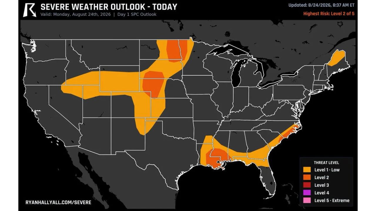
FARGO, N.D. — A Level 2 of 5 severe weather risk is targeting a broad, disconnected stretch of the country Monday, stretching from Nebraska and North Dakota down through Louisiana, putting roughly 6.9 million people in the path of damaging wind and large hail. The Storm Prediction Center’s Day 1 Outlook, updated at 8:37 a.m. ET, shows the corridor split into two separate hot zones hundreds of miles apart, each with its own timing and primary hazard.
The Two Threat Zones and When They Peak
The Level 2 risk area breaks down into distinct regions with different timing:
- Northern Plains (Nebraska, North Dakota): Hail is the headline threat, with Fargo’s hail window running from 4 p.m. to midnight, peaking near 6 p.m.
- Gulf Coast (Louisiana): Wind is the primary concern, with Baton Rouge’s wind threat peaking around 3 p.m. this afternoon
- Tornado risk: A few tornadoes are possible within the broader outlook area, but that risk covers a much smaller slice of the overall Level 2 zone
- Population exposure: Approximately 6.9 million people fall within the combined risk corridor
Why a Level 2 Designation Matters Here
A Level 2 risk sits in the middle of the SPC’s five-tier scale, signaling that scattered severe storms are expected, capable of producing large hail and damaging wind gusts, without the widespread, high-confidence coverage that would push a day into Level 3 or higher territory. What makes Monday’s setup notable isn’t the intensity of any single storm, but the geographic spread. Two separate clusters of severe potential, one anchored near Fargo and the northern Plains, the other near Baton Rouge and the Gulf Coast, are active on the same outlook day, meaning forecasters and residents in very different parts of the country are watching the same map for different reasons.
Where Things Stand as Storms Develop
As of this writing, storms have not yet fired across either threat zone, and this outlook reflects forecast risk rather than confirmed activity. No damage, outage, or injury reports have been published for either region. This article will be updated if confirmed storm reports or damage assessments become available following this afternoon and evening’s activity.
Severe Weather Safety Guide
Before storms arrive:
- Check your hail and wind timing: Fargo’s hail risk peaks near 6 p.m., while Baton Rouge’s wind threat peaks around 3 p.m.
- Move vehicles under cover if possible, especially ahead of the hail window in the northern Plains
- Secure loose outdoor items that could become projectiles in damaging wind gusts
- Identify your safe room: an interior room on the lowest floor, away from windows
When a warning is issued:
- Move away from windows immediately to avoid injury from hail impacts or flying debris
- Get to your safe room if a tornado warning is issued for your area
- Avoid parking under trees or power lines if caught while driving
After the storm passes:
- Inspect your vehicle and roof for hail damage once it’s safe to go outside
- Avoid downed power lines and treat all of them as live
- Check on neighbors, particularly in areas that saw the strongest wind gusts
A Coast-to-Coast Pattern Worth Watching
Monday’s outlook is a reminder that severe weather season doesn’t confine itself to one region at a time. With Level 2 risk simultaneously active near the Canadian border and along the Gulf Coast, the setup underscores how active the pattern remains heading into late August, with both hail-driven and wind-driven threats developing hundreds of miles apart on the same afternoon.
For more coverage like this, check back for the latest severe weather updates.