Skip to content

Home

About Us

Advertisement

Contact Us

  • Facebook
  • X
  • Instagram
  • Pinterest
  • WhatsApp
  • RSS Feed
  • TikTok

Dulaney Griffin

Your Trusted Weather Tracker.

Search

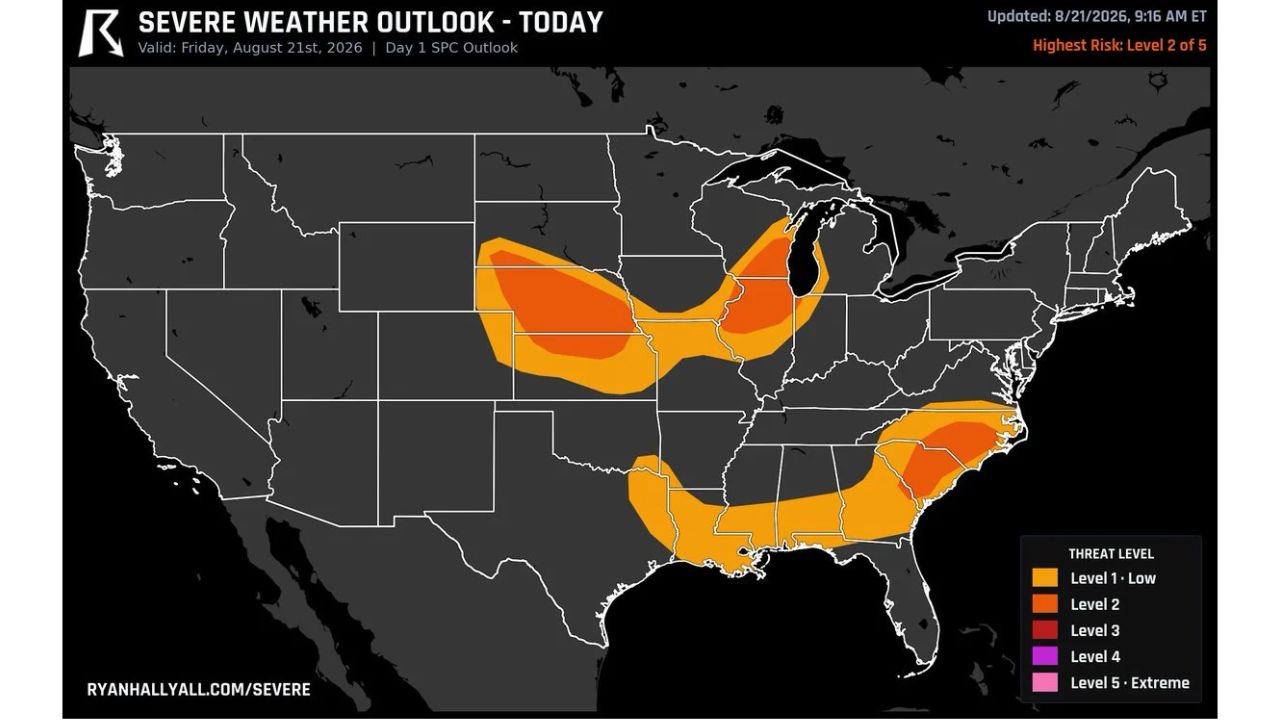
Nebraska, Chicago and the Carolinas Face Level 2 Severe Threat Today as 24 Million Brace for Storms That Could Bow Out Into Wind or Fire Up Into 2-Inch Hail

Melissa Peel Avatar
Melissa Peel
August 21, 2026
Nebraska, Chicago and the Carolinas Face Level 2 Severe Threat Today as 24 Million Brace for Storms That Could Bow Out Into Wind or Fire Up Into 2-Inch Hail

OMAHA, Neb. — A Level 2 severe weather risk covers Nebraska, Illinois and the Carolinas Friday, putting roughly 24 million people in the path of storms that carry genuine uncertainty in how they’ll behave. Over Nebraska, forecasters say the storms could either bow out into a damaging wind event or fire up into individual cells dropping hail over 2 inches, and they aren’t yet sure which outcome is more likely.

Timing varies sharply by region. Chicago’s best window for damaging wind runs from 3 to 9 p.m., peaking near 6 p.m., while Charlotte and Columbia face a similar wind risk that starts as early as 2 p.m. this afternoon, several hours ahead of the Chicago area.

Why the Nebraska Storms Carry Two Different Outcomes

What makes Nebraska’s piece of today’s outlook unusual is the genuine split in how forecasters expect it to play out. A storm system “bowing out” typically means individual cells merge into a fast-moving line capable of widespread straight-line wind damage, while storms that instead stay discrete and “fire up” can produce isolated but much larger hail, in this case, potentially exceeding 2 inches in diameter. Forecasters flagging this uncertainty openly, rather than defaulting to one scenario, signals the atmosphere over Nebraska hasn’t fully tipped its hand yet, meaning residents there may not know which specific hazard to prepare for until storms are already forming this afternoon.

Two Cities, Two Very Different Clocks

The outlook’s timing spread is just as notable as its geography. Charlotte and Columbia’s wind threat window opens at 2 p.m., putting the Carolinas’ risk period well ahead of the Midwest. Chicago, by contrast, doesn’t see its best wind window open until 3 p.m., running all the way to 9 p.m. with the sharpest risk concentrated around 6 p.m., meaning the Chicago area’s most dangerous stretch arrives closer to evening rush hour than the Carolinas’ does to midday.

What to Watch For as Friday Afternoon Unfolds

As of this writing, this is a Day 1 outlook with the day’s severe weather still ahead across all three highlighted regions. No severe thunderstorm watches tied to Nebraska, Chicago, or the Carolinas corridor have been issued yet. This article will be updated as watches, warnings, or storm reports develop through the afternoon and evening.

For more coverage like this, check back for the latest severe weather updates.

Featured Articles

  • Burns, Lakeview and Susanville Face Critical Fire Danger Saturday as 25 MPH Winds and 15 Percent Humidity Return to the Northwest

    Burns, Lakeview and Susanville Face Critical Fire Danger Saturday as 25 MPH Winds and 15 Percent Humidity Return to the Northwest

    August 21, 2026
  • Washington, Rockville and Baltimore Watch Sub-Severe Storm Line Approach as Warnings Possible Over Next Two Hours

    Washington, Rockville and Baltimore Watch Sub-Severe Storm Line Approach as Warnings Possible Over Next Two Hours

    August 21, 2026
  • Davenport to Milwaukee Face Quick Tornado Risk This Afternoon as Scattered Storms Develop Across Southern Wisconsin and Northern Illinois

    Davenport to Milwaukee Face Quick Tornado Risk This Afternoon as Scattered Storms Develop Across Southern Wisconsin and Northern Illinois

    August 21, 2026
  • Scattered Coastal Storms Develop Across North Carolina Including Jacksonville Wilmington and Central NC With Gusty Winds and Heavy Rainfall This Afternoon Evening

    Scattered Coastal Storms Develop Across North Carolina Including Jacksonville Wilmington and Central NC With Gusty Winds and Heavy Rainfall This Afternoon Evening

    August 21, 2026
  • Extreme Heat Warning Blankets Louisiana Along With Parts of Texas Arkansas and Mississippi as Dangerous Conditions Grip the Entire Gulf Coast Region

    Extreme Heat Warning Blankets Louisiana Along With Parts of Texas Arkansas and Mississippi as Dangerous Conditions Grip the Entire Gulf Coast Region

    August 21, 2026

Search

Follow Us on

  • Facebook
  • X
  • Instagram
  • VK
  • Pinterest
  • Last.fm
  • TikTok
  • Telegram
  • WhatsApp
  • RSS Feed

Categories

  • Forecast (8)

About Us

dulaneygriffin

Dulaney Griffin tracks storms, tornado risk, heat and snow across the United States, using National Weather Service and NOAA data. For active warnings in your area, always follow the National Weather Service and your local emergency officials.

Latest Articles

  • Burns, Lakeview and Susanville Face Critical Fire Danger Saturday as 25 MPH Winds and 15 Percent Humidity Return to the Northwest

    Burns, Lakeview and Susanville Face Critical Fire Danger Saturday as 25 MPH Winds and 15 Percent Humidity Return to the Northwest

    August 21, 2026
  • Washington, Rockville and Baltimore Watch Sub-Severe Storm Line Approach as Warnings Possible Over Next Two Hours

    Washington, Rockville and Baltimore Watch Sub-Severe Storm Line Approach as Warnings Possible Over Next Two Hours

    August 21, 2026
  • Davenport to Milwaukee Face Quick Tornado Risk This Afternoon as Scattered Storms Develop Across Southern Wisconsin and Northern Illinois

    Davenport to Milwaukee Face Quick Tornado Risk This Afternoon as Scattered Storms Develop Across Southern Wisconsin and Northern Illinois

    August 21, 2026

Categories

  • Forecast (8)
  • Instagram
  • Facebook
  • LinkedIn
  • X
  • VK
  • TikTok

Proudly Powered by WordPress | JetNews Magazine by CozyThemes.

Scroll to Top